315 papers
First Direct Observations of Internal Flow Structures in a Powder Snow Avalanche: Turbulence, Instability and Particle Distribution
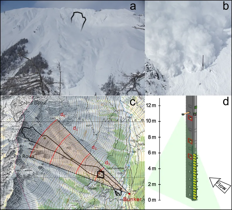
Powder snow avalanches are highly dynamic, multiphase gravity-driven flows typically composed of a dense basal layer overlain by airborne layers in which snow particles are suspended within a turbulent air phase. Despite extensive work on related systems such as pyroclastic density currents and turbidity currents, all gravity current communities face a fundamental limitation: the lack of direct, high-resolution particle-scale field data. Here, we present the first direct optical observations of individual particle motion inside the airborne layers of a natural powder snow avalanche using high-speed imaging. The flow is segmented into three regions: an initial short living surge, a highly dynamic suspension phase, and a final wake. Across these phases, we quantify flow velocity and turbulence characteristics, including integral length scales, and use image intensity as a proxy for particle concentration. We identify fluctuations exceeding the turbulent integral scale and use linear stability analysis to link them to Kelvin-Helmholtz-type shear instabilities. Observed changes in clustering behavior, stratification, and the decoupling of particles from the flow mark the transition from an unstable suspension layer characterized by a high level of turbulent activity to a stable one dominated by passive snow settling. Together, these findings provide the first empirical constraints on turbulence and instability dynamics in airborne avalanche layers, with direct implications for the refinement of numerical avalanche models and closure schemes in multiphase gravity current simulations.
2603.28144Mar 2026
View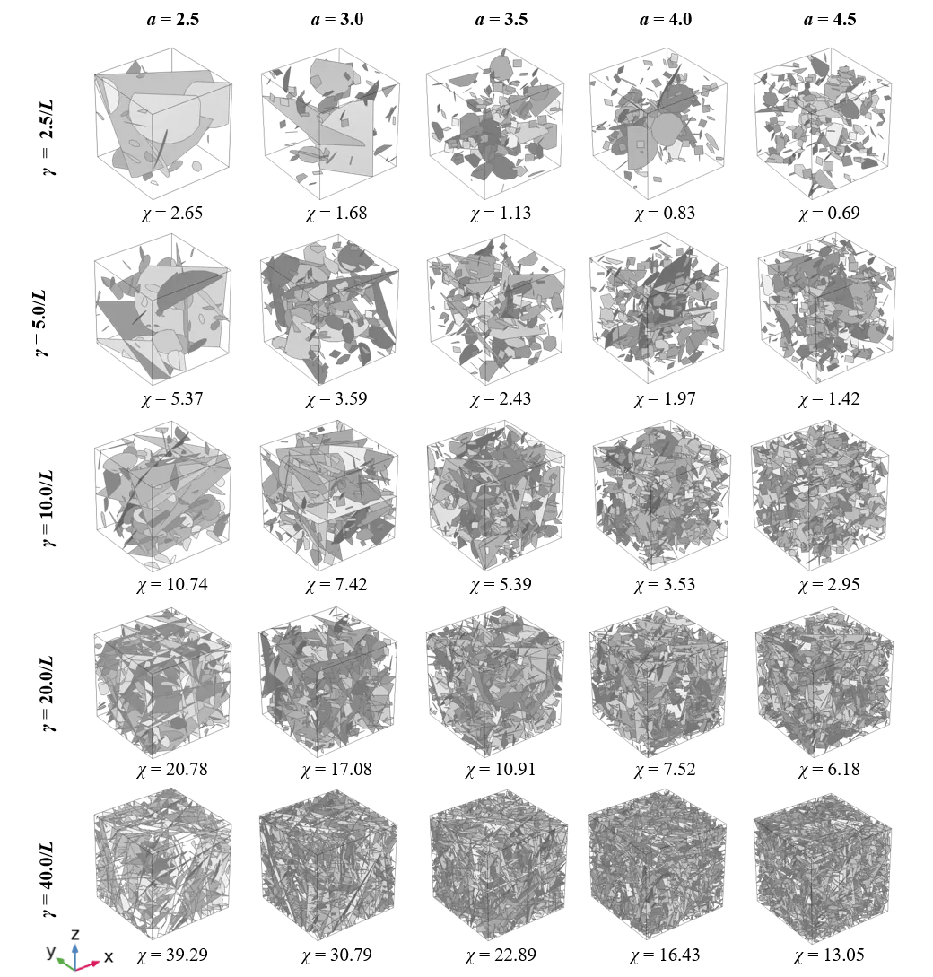
Two-branch retention behavior in unsaturated fractured rock driven by fracture-matrix flow partitioning
Upscaling unsaturated flow in fractured rock remains challenging because fractures and matrix often exhibit sharply contrasting hydraulic behaviors across saturation states. Here, we demonstrate that unsaturated flow undergoes a transition between matrix- and fracture-dominated regimes. Three-dimensional direct numerical simulations reveal that both relative permeability and capillary pressure curves display a robust two-branch structure. We analytically derive a generalized retention formulation that identifies a critical saturation marking the transition between the two distinct retention regimes and reproduces the two-branch behavior captured in the numerical simulations. An analytical expression for the critical pressure head is further derived to represent the limiting case of fully connected fracture networks, providing a physical explanation for the retention regime shift and showing good agreement with the numerical results for systems above the percolation threshold. Our results provide a mechanistic framework for understanding and upscaling unsaturated flow in fractured rock, with broad implications for hydrology and geophysics.
2603.26605Mar 2026
View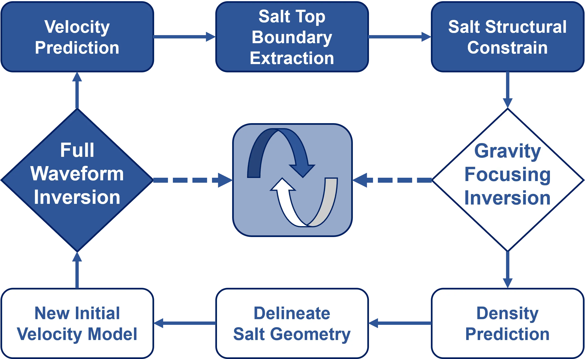
A Multi-physics Alternating Coupled Inversion Using Gravity and Full Waveform Data in Salt Dome
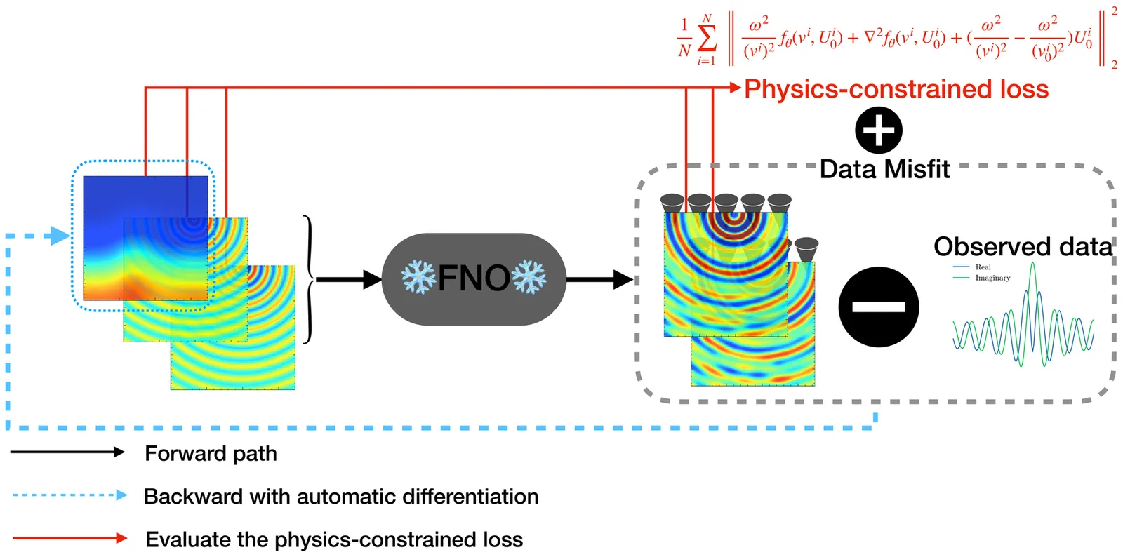
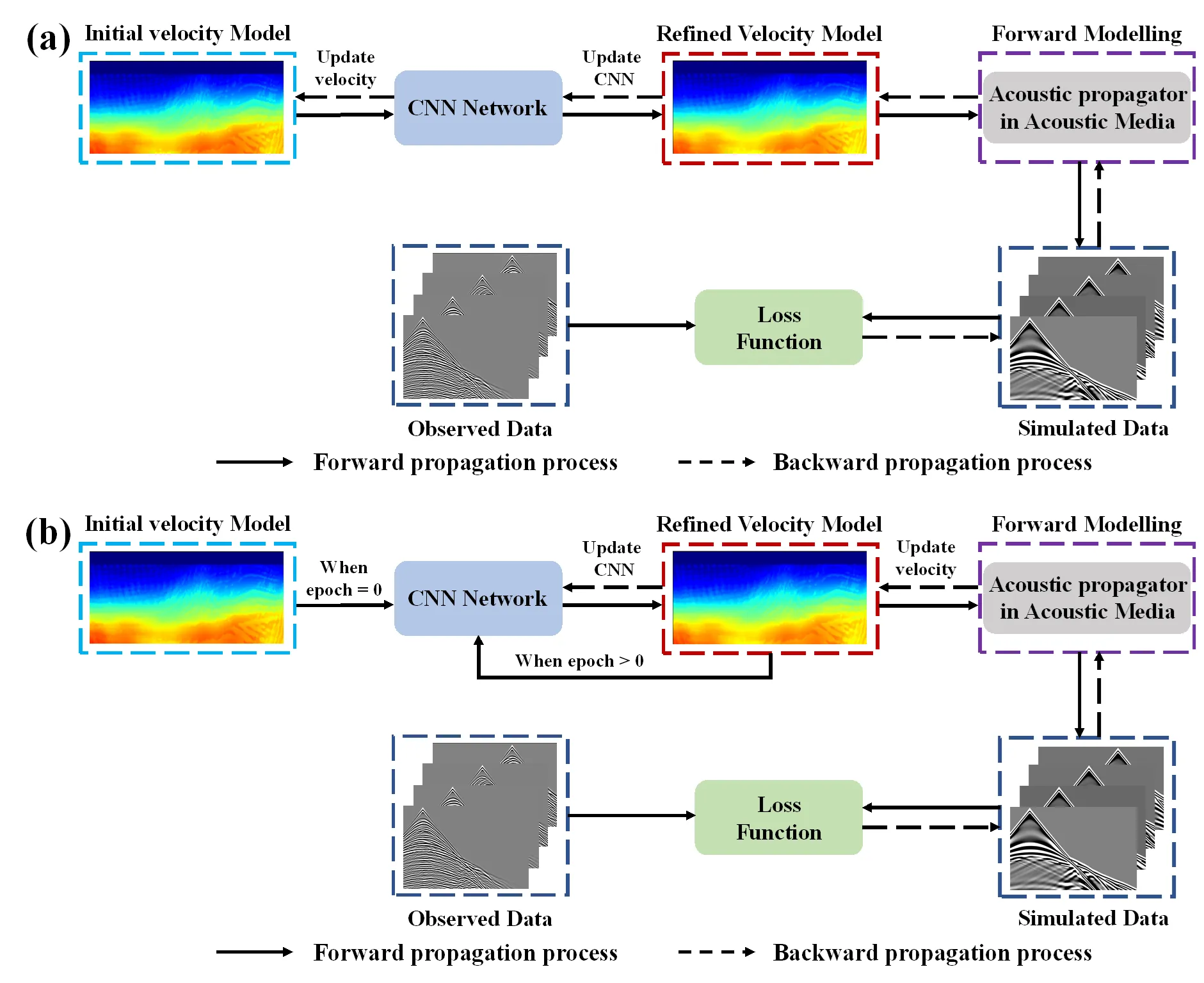
Complex salt geometries and strong velocity contrasts pose significant challenges for velocity model building and subsalt imaging. Although full waveform inversion (FWI) provides high-resolution velocity models, its performance strongly depends on the accuracy of initial model. On the other hand, gravity focusing inversion (GFI) can recover compact density distributions and provide reliable long-wavelength structural information for seismic exploration, but it suffers from poor depth resolution and inherent non-uniqueness. To better invert salt structure by leveraging the complementary advantages of full waveform and gravity data, we propose a multi-physics alternating coupled inversion strategy for salt dome model. The proposed strategy mainly includes three parts. First, we perform FWI using a simple layered velocity model to obtain preliminary velocity updates and extract the salt top boundary. Second, this structural information is used as a constraint in GFI to recover a compact salt density distribution beneath the salt top. Third, the resulting salt geometry is used to construct an improved velocity model for the next stage of FWI. Through iterative alternation, FWI provides reliable structural constraints for GFI, while GFI supplies a more reasonable macroscopic salt model for FWI, effectively mitigating the strong dependence on the initial model. In addition, a depth-varying density contrast is introduced in GFI to better represent sediment compaction effects. Compared with unconstrained GFI and conventional FWI using a horizontally layered initial model, the proposed method effectively improves both velocity and density reconstruction in the modified BP salt model and SEG/EAGE salt model.
2603.26191Mar 2026
View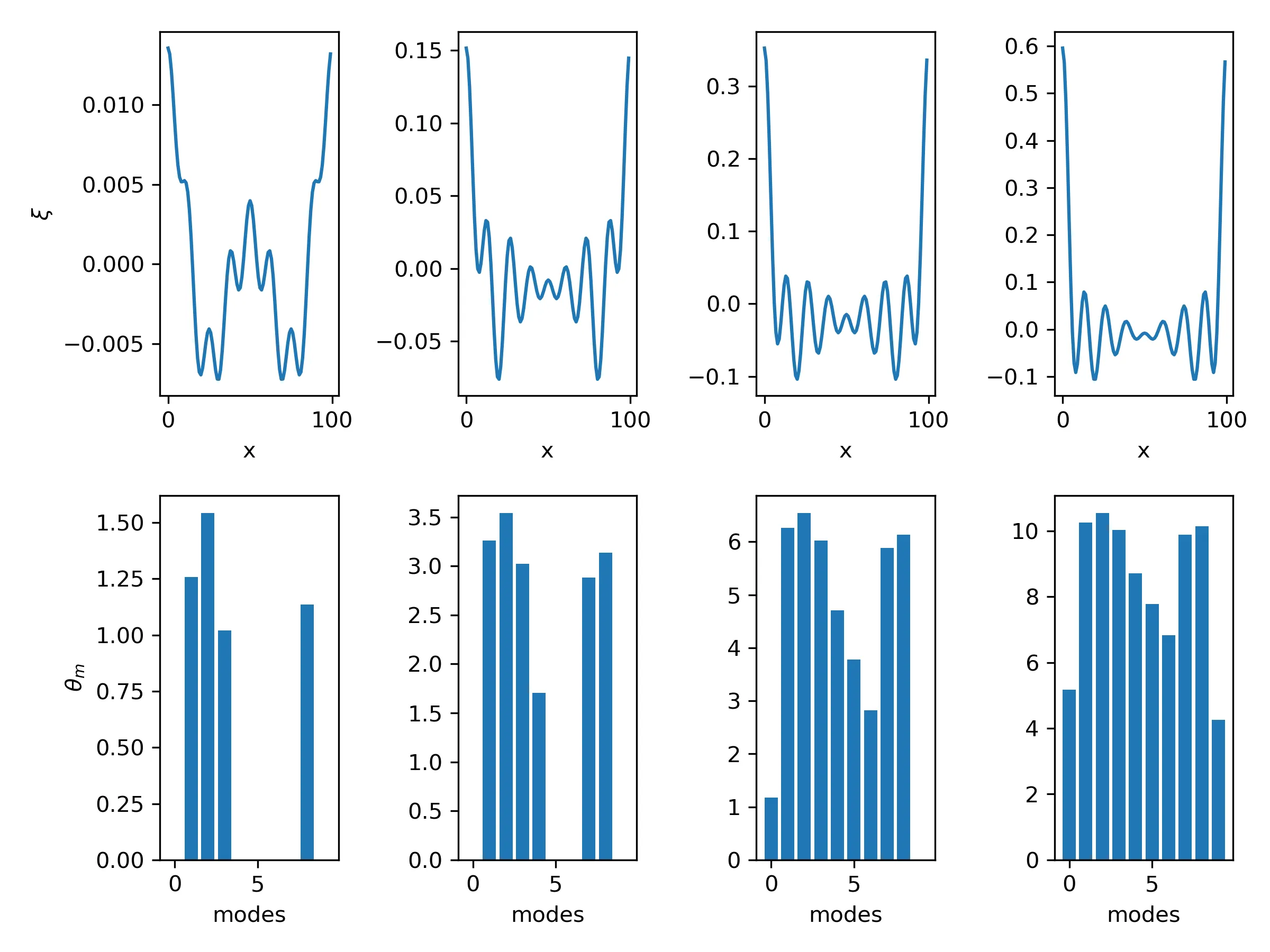
Transdimensional Data Assimilation for dynamic model selection problems
In this paper we combine the non-linear filtering capabilities of particle filters with the transdimensional inference of the reversible-jump Markov chain Monte Carlo method for a data assimilation methodology over dynamic problems with variable dimensionality. By using transdimensional MCMC steps for the rejuvenation of the particle filter, the algorithm could change the number of state space parameters on the fly and can be applied for transdimensional data assimilation purposes. Classic inversion methodologies use pre-defined models, and only changes the individual parameter values during interpretation. This is often not feasible when the optimal model parametrization is not known a priori or when the model resolution needs to change with time. The proposed transdimensional particle filter algorithm, combines the advantages of particle filters and the transdimensional MCMC methods, and provides an easily implementable data assimilation algorithm that could tackle such problems. The methodology could also improve the computational efficiency of particle filters as it could inherently optimize the model complexity in a data-driven way. We demonstrate the capabilities of the enhanced algorithm on two simple model examples.
2603.25318Mar 2026
View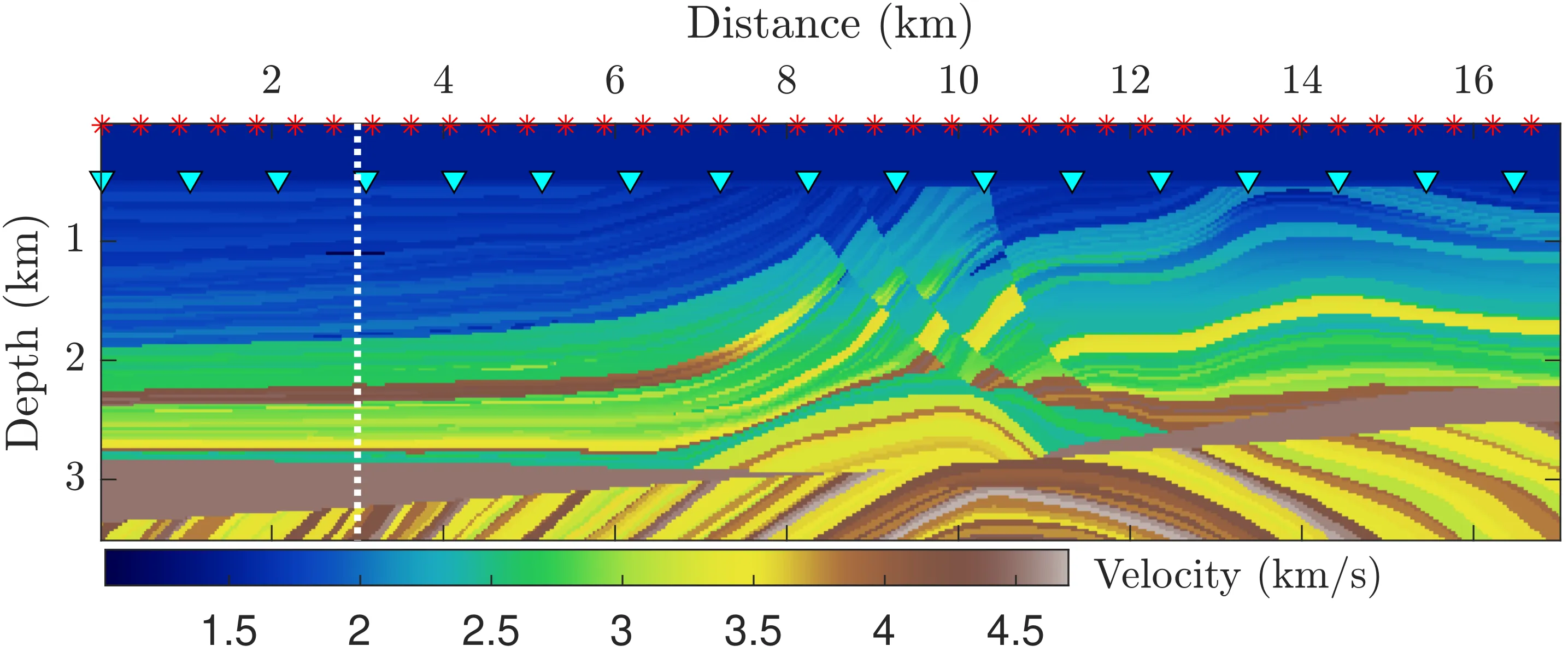
Scalable Bayesian full waveform inversion via dual augmented Lagrangian SVGD
Full waveform inversion is an ill-posed inverse problem whose solution non-uniqueness -- i.e., arising from band-limited, finite-aperture, noisy data -- calls for uncertainty quantification to avoid overconfident geological interpretations. Bayesian inference addresses this need by characterizing the solution as a posterior distribution rather than a single point estimate. Sampling from this distribution, however, remains computationally challenging: Markov chain Monte Carlo and non-amortized variational inference require repeated wave equation solves, while amortized variational inference approaches that avoid repeated solves rely on training data that are inherently scarce in geoscience and face unresolved generalization challenges in high dimensions. To address these limitations, we integrate Stein variational gradient descent with the alternating direction method of multipliers under a dual augmented Lagrangian formulation. By fixing the wave operator at a background model that is updated between frequency batches, it need only be factorized once per particle per frequency, eliminating per-iteration refactorization and reducing the total cost to that of a handful of deterministic inversions while inheriting the favorable conditioning of extended-space formulations. Applied to the Marmousi~II model, the proposed method provides well-calibrated uncertainty estimates and achieves inversion quality comparable to that of the standard augmented Lagrangian SVGD at a fraction of the computational cost.
2603.24751Mar 2026
View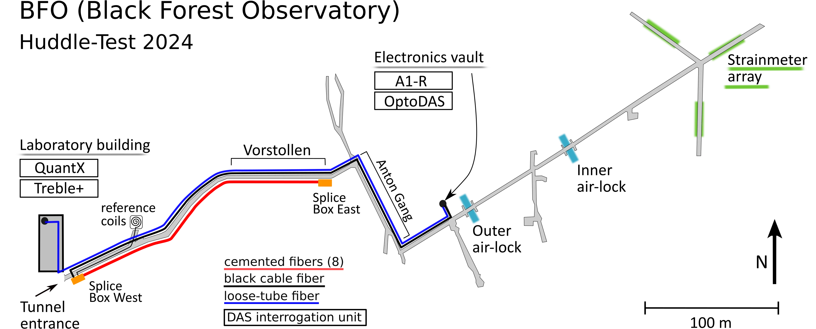
Cemented fibers as a testbed for distributed acoustic sensing (DAS)
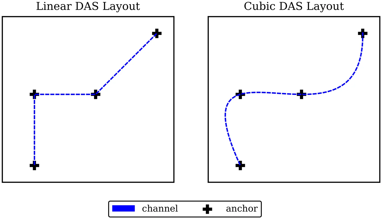
A rigid connection between the optical fiber and the rock makes amplitudes of 'fiber strain' measured with Distributed Acoustic Sensing (DAS) equal to 'rock strain'. We demonstrate this by running four interrogator units (IU) on a DAS testbed with single-fiber patch cables being cemented into a groove in the concrete floor of Black Forest Observatory (BFO). The recorded signals are compared with the recordings of a calibrated Invar wire strain meter array that has been continuously in operation for the last decades. This way we measure 'strain transfer rate' (ratio of 'fiber strain' over 'rock strain') at frequencies below 0.2 Hz. Waveform similarity for strong earthquake signals is high with typical values of the normalized correlation coefficient greater than 0.95. The 'strain transfer rate' is close to 1 for all four IUs, while it was significantly less in a previous study with DAS cables unreeled on the floor and loaded down by sand and sandbags, only. At frequencies up to 14 Hz we make an intercomparison of IUs, showing no significant variation with frequency. The scatter of 'strain transfer rate' in between channels which are spatially near to each other in the same fiber route is about $\pm$10 % in most cases. The variation of median values in between different IUs and earthquakes is less than 5 %. By subtracting the common mode laser noise, which is coherent along the fiber route, we lower the background signal level to an rms-amplitude of 100 pstrain at 0.1 Hz and 5 pstrain at 1 Hz in a bandwidth of 1/6 decade for the best cases. This allows the detection of the marine microseisms during times of moderate amplitude level.
2603.24353Mar 2026
View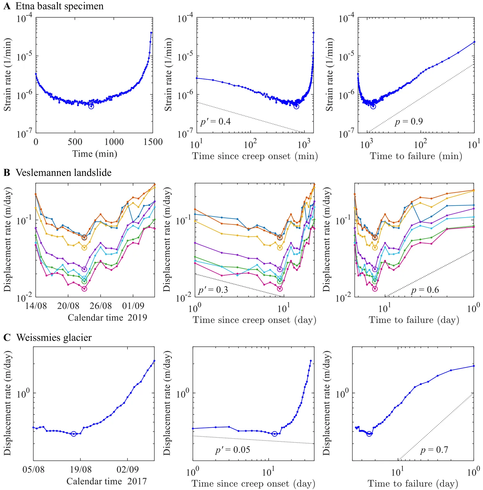
Primary creep encodes time to failure across laboratory and natural systems
Geomaterials often exhibit progressive creep characterized by an initial decelerating phase, frequently followed by an extended period of approximately constant deformation rate, and ultimately an accelerating regime leading to catastrophic failure. Despite extensive research, the timing of rupture and its relationship to the different creep phases, particularly in natural systems, remain poorly constrained. Here, we compile creep data from laboratory experiments on rocks, composites, papers, and glasses, together with observations from field systems including landslides, rockfalls, and glaciers. We find that the duration of the early-stage creep, marked by the transition to the minimum (or quasi-stationary) deformation rate, correlates nearly linearly with the time to rupture over five orders of magnitude. This unified scaling highlights that the early-time dynamics reflect the full evolution toward failure, providing a simple and robust framework for forecasting rupture across laboratory and natural systems.
2603.24081Mar 2026
View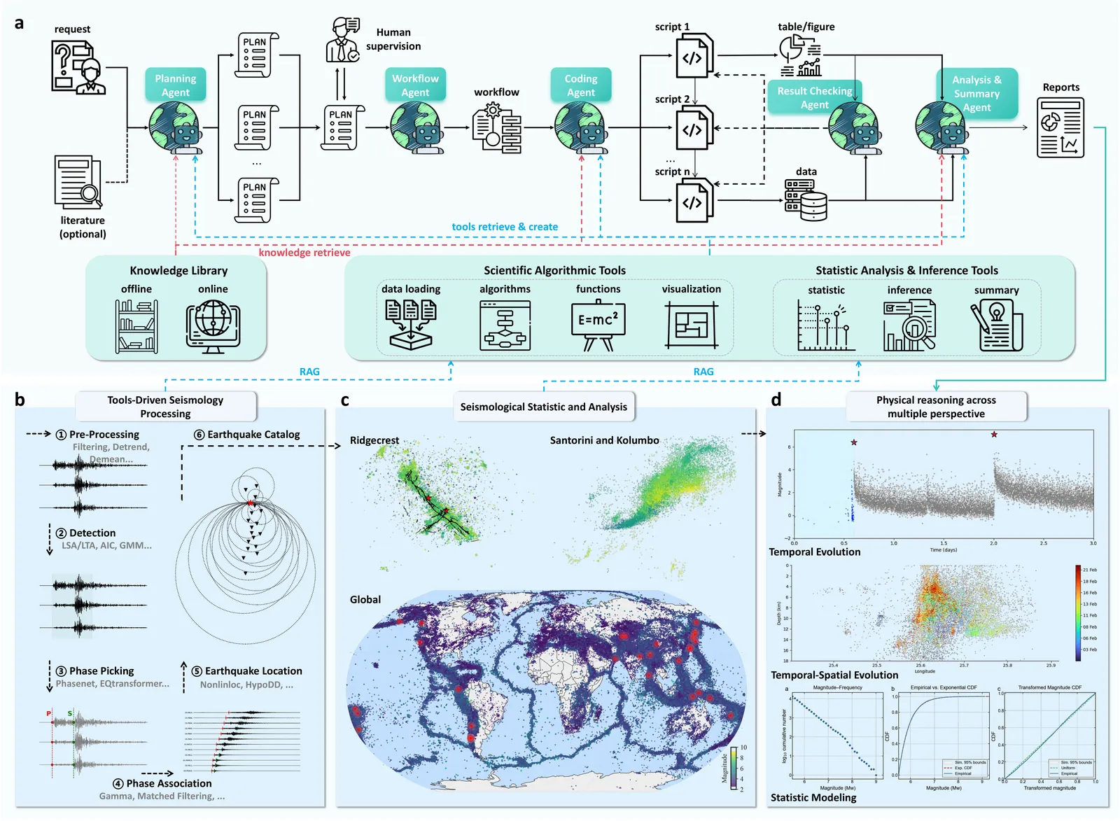
TRACE: A Multi-Agent System for Autonomous Physical Reasoning for Seismology
Inferring physical mechanisms that govern earthquake sequences from geophysical observations remains a challenging task, particularly across tectonically distinct environments where similar seismic patterns can reflect different underlying processes. Current seismological processing and interpretation rely heavily on experts' choice of parameters and the synthesis of various seismological products, limiting reproducibility and the formation of generalizable knowledge across settings. Here we present TRACE (Trans-perspective Reasoning and Automated Comprehensive Evaluator), a multi-agent system that combines large language model planning with formal seismological constraints to derive auditable, physically grounded mechanistic inferences from raw observations. Applied to the 2019 Ridgecrest sequence, TRACE autonomously identifies stress-perturbation-induced delayed triggering, resolving the cascading interaction between the Mw 6.4 and Mw 7.1 mainshocks. For the 2025 Santorini-Kolumbo volcanic eruption, the system identifies a structurally guided intrusion model, distinguishing episodic migration via fault channels from the continuous propagation expected in homogeneous crustal failure. By providing a generalizable infrastructure for deriving physical insights from seismic phenomena, TRACE advances the field from expert-dependent analysis toward knowledge-guided autonomous discovery in Earth sciences.
2603.21152Mar 2026
View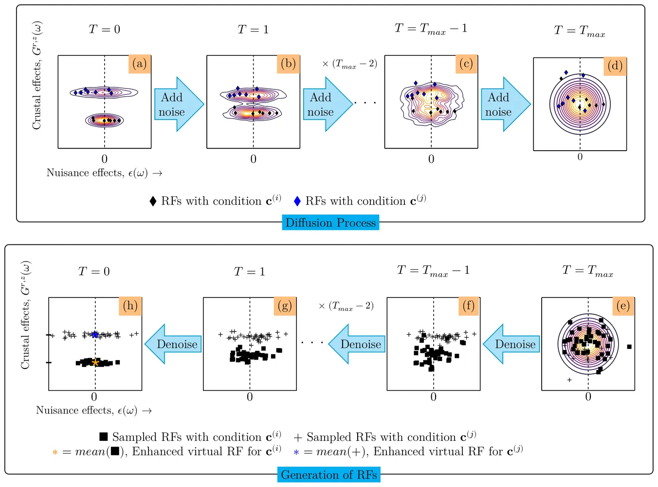
Virtual receiver functions via conditional diffusion transformers for robust crustal imaging
Receiver functions (RFs) are widely used to image crustal and upper-mantle structure, and their variation with backazimuth and epicentral distance contains key information about layering and azimuthal anisotropy. In practice, however, RFs are contaminated by nuisance effects from unknown earthquake source signatures and seismic noise, which obstruct reliable crustal imaging. Sparse RF coverage across backazimuths and epicentral distances also leads to biased anisotropy estimates. We address these challenges using conditional diffusion models, conditioned on backazimuth, epicentral distance, and station coordinates, to produce high-quality virtual radial and transverse RFs. RFs from earthquakes with similar backazimuths and epicentral distances share consistent crustal responses but differ in nuisance effects, allowing the model to suppress the latter. Our framework generates virtual RFs within gaps in backazimuth and epicentral distance coverage, enhancing the interpretation of crustal anisotropy and layering. On synthetic RFs with realistic non-Gaussian noise, virtual RFs correlate more strongly with the true RFs than traditional linear or phase-weighted stacking. Applied to the Cascadia Subduction Zone, virtual radial RFs sharply image scattered S-waves from the dipping slab, with enhanced phase clarity and backazimuthal coverage relative to previous work. In southern California, anisotropy parameters inferred from virtual RFs are spatially coherent and consistent with regional fault geometry. Our approach leverages all available RFs, regardless of quality, to increase spatial coverage and support robust, automated RF analysis.
2603.20902Mar 2026
View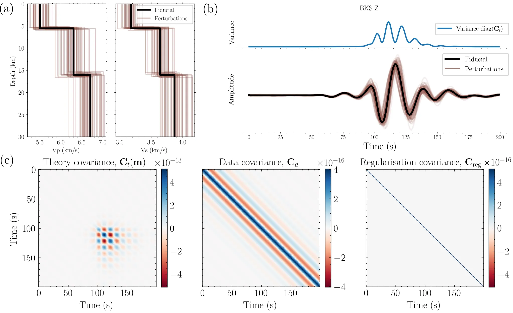
Improving moment tensor solutions under Earth structure uncertainty with simulation-based inference
Bayesian inference represents a principled way to incorporate Earth structure uncertainty in full-waveform moment tensor inversions, but traditional approaches generally require significant approximations that risk biasing the resulting solutions. We introduce a robust method for handling theory errors using simulation-based inference (SBI), a machine learning approach that empirically models their impact on the observations. This framework retains the rigour of Bayesian inference while avoiding restrictive assumptions about the functional form of the uncertainties. We begin by demonstrating that the common Gaussian parametrisation of theory errors breaks down under minor ($1-3 \%$) 1-D Earth model uncertainty. To address this issue, we develop two formalisms for utilising SBI to improve the quality of the moment tensor solutions: one using physics-based insights into the theory errors, and another utilising an end-to-end deep learning algorithm. We then compare the results of moment tensor inversion with the standard Gaussian approach and SBI, and demonstrate that Gaussian assumptions induce bias and significantly under-report moment tensor uncertainties. We also show that these effects are particularly problematic when inverting short period data and for shallow, isotropic events. On the other hand, SBI produces more reliable, better calibrated posteriors of the earthquake source mechanism. Finally, we successfully apply our methodology to two well studied moderate magnitude earthquakes: one from the 1997 Long Valley Caldera volcanic earthquake sequence, and the 2020 Zagreb earthquake.
2603.18925Mar 2026
View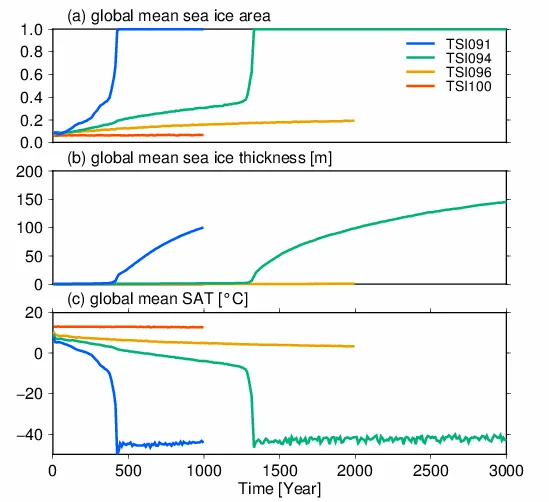
Climate and ocean circulation changes toward a modern snowball Earth
It has been hypothesized that the Earth may have experienced snowball events in the past, during which its surface became completely covered with ice. Previous studies used general circulation models to investigate the onset and climate of such snowball events. Using the MIROC4m coupled atmosphere--ocean climate model, this study examined the changes in the oceanic circulation during the onset of a modern snowball Earth and elucidated their evolution to steady states under the snowball climate. Abruptly changing the solar constant to 94% of its present-day value caused the modern Earth climate to turn into a snowball state after ~1300 years and initiated rapid increase in sea ice thickness. During onset of the snowball, extensive sea ice formation and melting of sea ice in the mid-latitudes caused substantial freshening of surface waters and salinity stratification. By contrast, such salinity stratification was absent if the duration between the change in the solar flux and the snowball onset was short. After snowball onset, the global sea ice cover and the buildup of salinity stratification caused drastic weakening in the deep ocean circulation. However, the meridional overturning circulation resumed within several hundred years after the snowball onset because the density flux by sea ice production weakens the salinity stratification. While the evolution of the oceanic circulation would depend on the continental distribution and the evolution of continental ice sheets, our results highlight the gradual growth of sea ice and associated brine rejection are essential factors for the transient evolution of the oceanic circulation in the snowball events.
2603.26700Mar 2026
View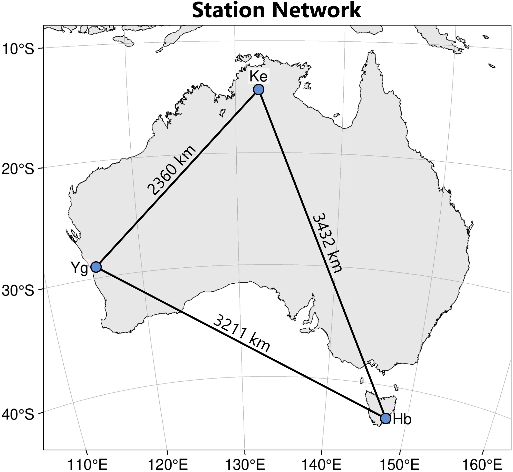
Comprehensive VLBI observations of Galileo satellites with the AuScope array
Interest in the topic of geodetic co-location in space and space ties has recently intensified within the geodetic community, particularly following the approval of the European Space Agency's (ESA) Genesis mission. From the perspective of Very Long Baseline Interferometry (VLBI), observations of Earth-orbiting satellites are not standard practice yet. To enable VLBI support for future colocation satellite missions, such observations must be integrated into the VLBI processing chain. In this study, we present comprehensive VLBI observations of Galileo navigation satellites conducted with the Australian AuScope VLBI array. Using the 12-m antennas in Hobart, Katherine and Yarragadee equipped with VLBI Global Observing System (VGOS) instrumentation, Galileo E1 and E6 signals were observed in test experiments and a series of four full-scale 24-hour observing sessions. We present the estimation of VLBI station coordinates from observations to navigation satellites, thereby demonstrating, for the first time, inter-technique ties between the VLBI and Global Navigation Satellite System (GNSS) frame. We describe the processing strategy, including correlation, fringe fitting, precision assessment and satellite tracking approach. Delay observables achieve precisions of a few picoseconds in the E1 band and several tens of picoseconds in the E6 band for 1-s integration times. However, unmodelled signals on the order of several hundred picoseconds are found in the residual delays. Estimated station coordinates agree with a priori values at the metre level, while baseline lengths agree at the sub-metre level. These results demonstrate the feasibility of large-scale VLBI observations to GNSS satellites and provide critical groundwork for future co-location satellite missions such as Genesis.
2603.16955Mar 2026
View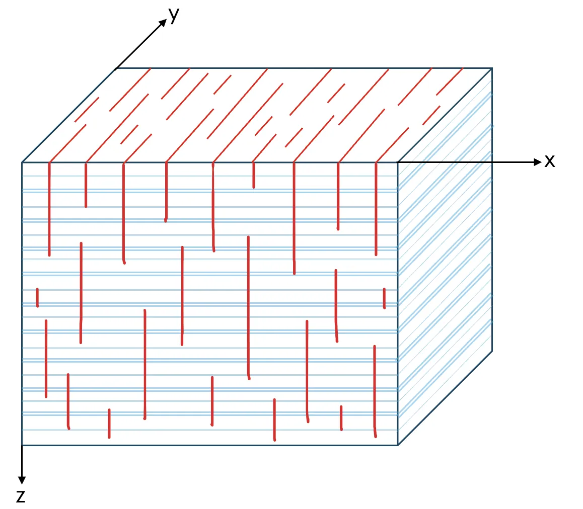
Elastic waveform inversion for double-couple microseismic source estimation in vertically fractured transversely isotropic media
Accurate characterization of microseismic events during fluid injection in sedimentary formations is essential to mitigate environmental risks. The source mechanism for microseismic events related to a slip on a fault plane is given by a double-couple. Waveform inversion has emerged as a promising technique for estimating the moment tensor and the position vector of double-couple sources. In most applications of waveform inversion for the moment tensor of double-couple sources, the formation is typically assumed to be isotropic or, less frequently, transversely isotropic. Modification of the moment-tensor representation to account for anisotropy created by aligned vertical fractures in transversely isotropic formations has not been included while inverting microseismic waveform data. In this study on synthetic microseismic data, we present a waveform inversion algorithm that includes this modification, considering the formation in the focal region to be vertically fractured transversely isotropic (VFTI) and possessing orthorhombic symmetry. Since VFTI media lack rotational symmetry, no assumptions have been made about the orientation of the fault plane where the slip occurred. The moment tensor of double-couple sources is formulated in terms of the elastic parameters of the VFTI medium and geometrical parameters which are slip magnitude, slip angle, fault dip, and azimuth angle of the fault-normal. Source inversion is treated as a local optimization problem, and we invert for the source location and the geometrical parameters. These geometrical parameters are more directly constrained by seismic data than the moment tensor components and offer geologically meaningful insights. This approach enhances microseismic monitoring in fractured formations and can be extended to more complex anisotropic media, such as monoclinic systems.
2603.15982Mar 2026
View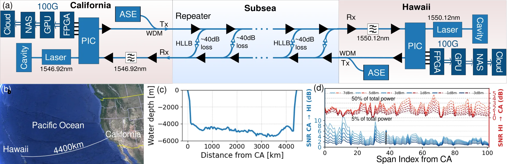
High-Resolution Trans-Oceanic Distributed Acoustic Sensing Enabled by a Bi-Directional Sensor Implementation
We demonstrate continuous distributed acoustic sensing over a 4400km long undersea cable. Bi-directional operation improves the strain signal-to-noise rate by >20dB, enabling 88000 50-m-spaced measurement points at a nominal telecom launch power.
2603.15828Mar 2026
View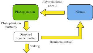
A Data-Constrained Framework for Marine Biogeochemistry Modeling with Applications to the Paranaguá Estuarine Complex
Marine biogeochemical models are widely used to study nutrient dynamics, water quality, and climate-related processes in coastal and estuarine systems. However, developing models that reliably represent specific environments remains computationally demanding, which makes their application to complex systems such as river plumes and estuarine environments challenging. In addition, these models contain several parameters that must be calibrated for the region of interest, a process that is often performed empirically using limited observational data. This thesis advances the development and calibration of marine biogeochemical models in the Brazilian context through three main contributions. First, we develop a conceptual model describing nutrient-phytoplankton dynamics in the Paranagua Estuarine Complex (PEC) in southern Brazil. The model is intentionally simple and computationally inexpensive, allowing simulations to be performed on standard personal computers. Second, we propose a systematic calibration framework based on tracer datasets and derivative-free optimization techniques. Finally, we demonstrate the practical application of this approach by calibrating the PEC model using in situ observations. Results show that, despite its simplicity, the model can reproduce observed nutrient dynamics when properly calibrated. The proposed framework is general and can be extended to multi-parameter calibration, seasonal parameter variation, and the coupling of biogeochemical models with higher-fidelity hydrodynamic models.
2603.15580Mar 2026
View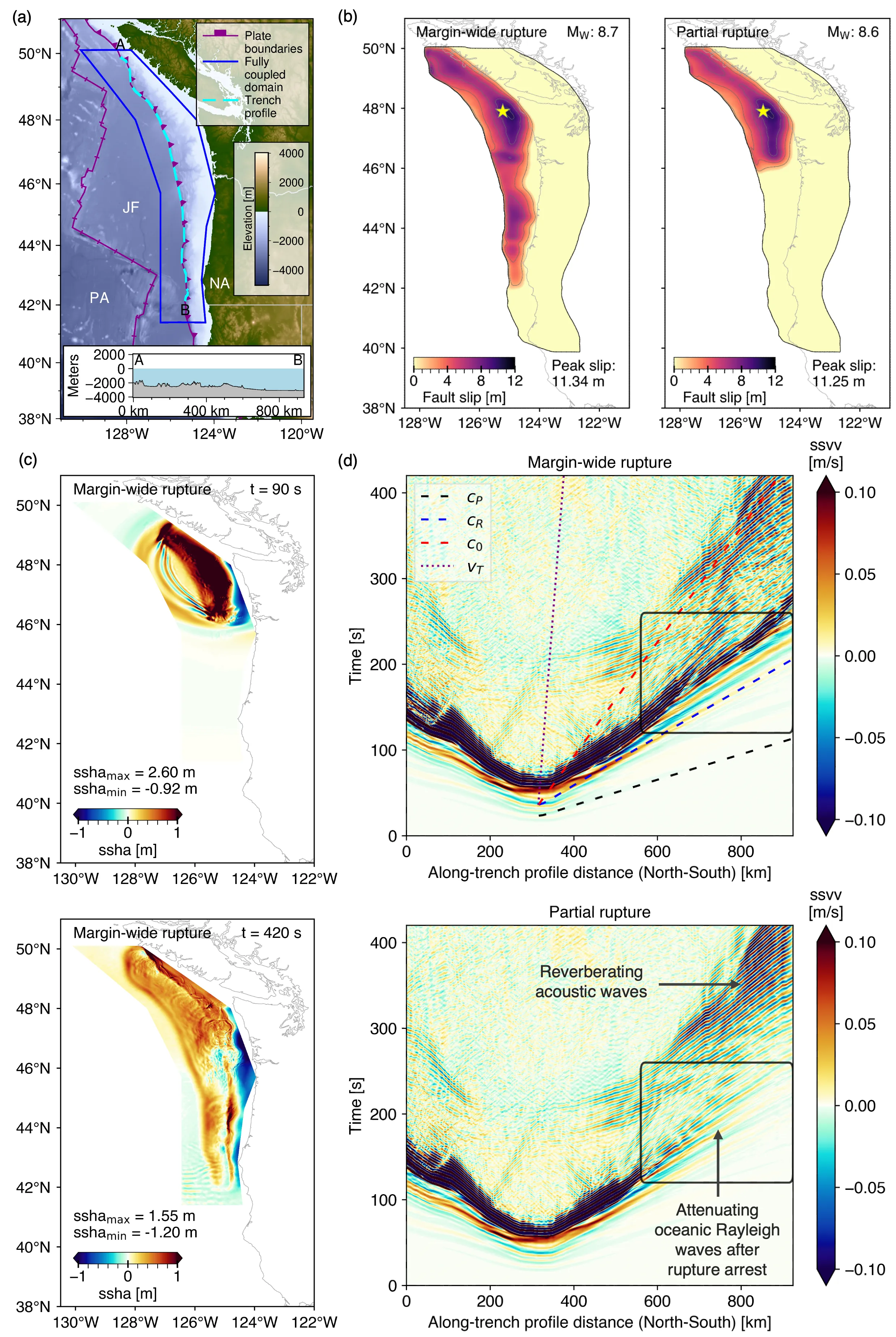
Real-time probabilistic tsunami forecasting in Cascadia from sparse offshore pressure observations
Near-field tsunami early warning in the Cascadia Subduction Zone is limited by sparse offshore observations. We show that a hypothetical network of 175 seafloor pressure sensors can support real-time Bayesian inference of tsunamigenic seafloor motion and probabilistic tsunami forecasts for two fully-coupled Cascadia earthquake dynamic rupture--tsunami scenarios, a partial rupture and a margin-wide rupture. The complex oceanic acoustic, Rayleigh, and tsunami wavefields in both scenarios are similar during the first two minutes and then diverge. Using an acoustic--gravity inversion with offline precomputation and online assimilation of pressure data, tsunami forecasts are obtained in less than a second. We leverage a Bayesian inversion-based framework that splits the computations into an offline precomputation phase performed with large-scale computing facilities, and an online phase that computes forecasts from real-time data and can be executed on a laptop. Forecast errors remain low at 22.1% for the margin-wide rupture and 19.6% for the partial rupture.
2603.14966Mar 2026
View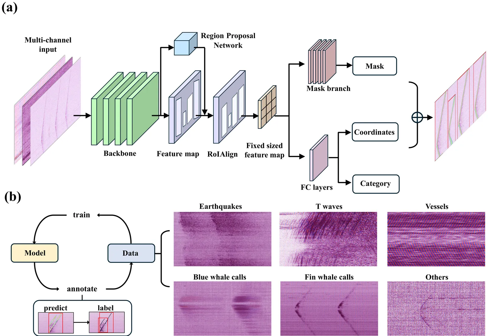
A deep learning framework for marine acoustic and seismic monitoring with distributed acoustic sensing
Distributed Acoustic Sensing (DAS) enables high-resolution and long-duration monitoring of marine acoustic and seismic activity by turning existing fiber-optic cables into dense sensor arrays. However, extracting diverse signals from continuous DAS data remains challenging due to the massive data volumes and signal complexity. Here, we present DASNet, a deep learning framework for automated detection, classification, and arrival-time picking of diverse marine signals in DAS data. The model is trained using a semi-supervised pipeline on continuous recordings and jointly predicts spatiotemporal bounding boxes and segmentation masks for each detected event. Applied to three years of data from the Seafloor Fiber-Optic Array in Monterey Bay (SeaFOAM), DASNet identified over 500,000 events spanning multiple signal categories. For seismic monitoring, the model detects the majority of cataloged local earthquakes within 100 km and identifies distant earthquake-generated T-waves, with beamforming analysis revealing source azimuths clustered toward the southwestern Pacific and along mid-ocean ridge systems. For bioacoustic monitoring, DASNet detects and tracks more than 400,000 blue and fin whale calls, revealing seasonal and interannual variability consistent with independent hydrophone records. For anthropogenic activity, DASNet detects and localizes vessel traffic near the cable, with estimated positions validated against Automatic Identification System (AIS) tracks. These results demonstrate that combining DAS with deep learning provides a scalable, high-resolution monitoring approach for marine environmental observation. As submarine DAS deployments expand, this framework could substantially enhance seismic, bioacoustic, and anthropogenic observations in regions where conventional instrumentation remains sparse.
2603.14844Mar 2026
View 2603.14759
Thermodynamic criticality in seismicity: Uniqueness of surface-energy scaling in the fragment-asperity model
We propose that a linear relation between the energy of stress-bearing interactions and the surface of contact within the fragment-asperity model for earthquakes. It reveals as the only one that leads to a closed elementary form for a well-defined total entropy as a function of non-extensivity parameter, $q$. By writing the total Tsallis entropy as a function of $q$, a critical range of values is identified: $1.4\lesssim q\lesssim 1.8$. Such interval of $q$-values corresponds to the strong variation of entropy and contains the most of reported results for this parameter determined for main-shocks around the world in recent decades, indicating the role of $q$ as a criticality indicator, more than just a fitting parameter.
2603.14759Mar 2026
View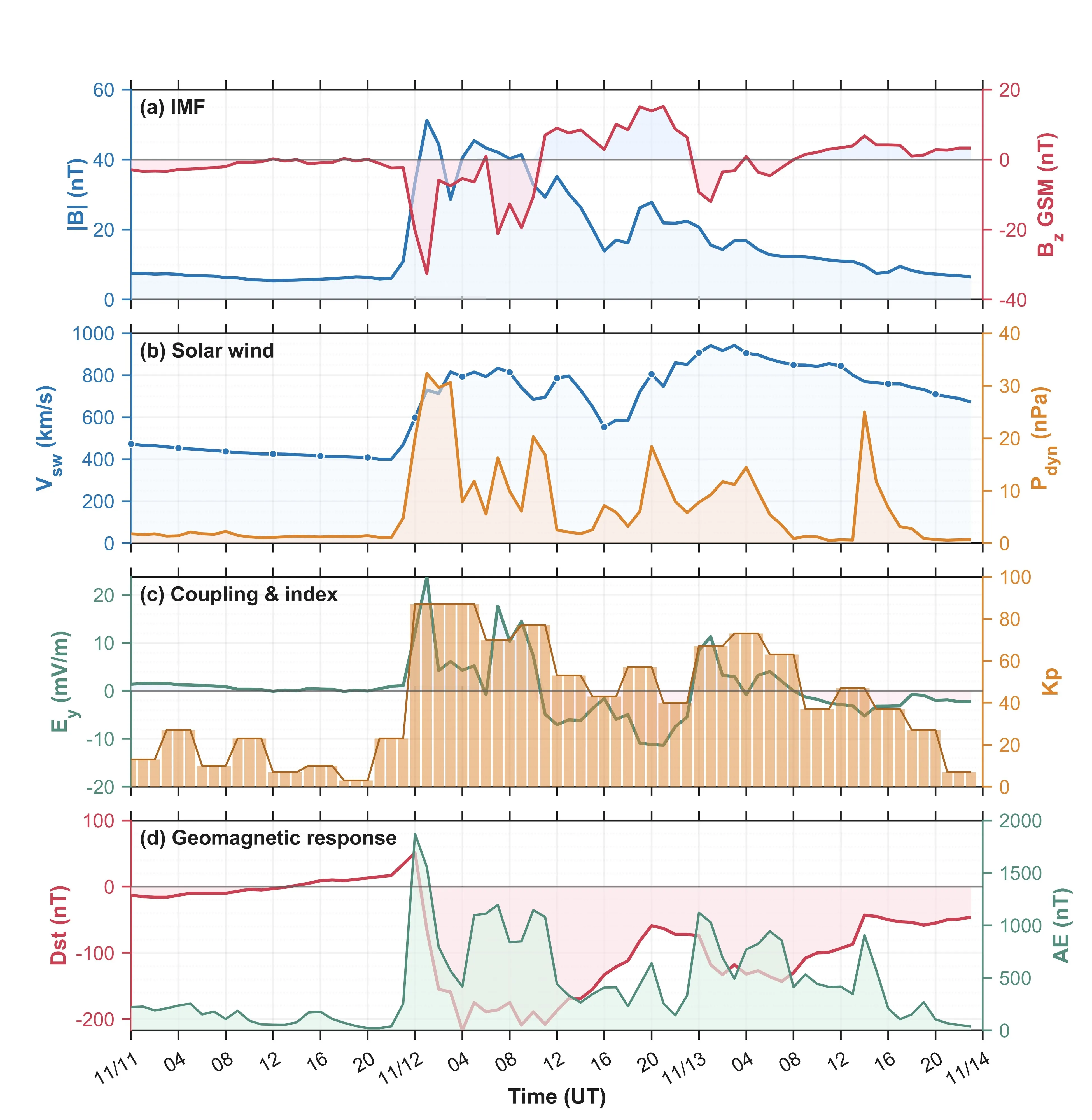
Multi-instrument constraints on a hemispherically asymmetric positive ionospheric storm in the 60-180 deg E sector during the 12-13 November 2025 geomagnetic storm
Geomagnetic storms drive complex ionospheric responses through coupled electrodynamic and thermospheric processes, yet attributing storm-time TEC perturbations to specific mechanisms remains challenging. We investigate the ionospheric response to the 12-13 November 2025 intense geomagnetic storm (Dst minimum = -214 nT) in the 60-180 deg E sector using a coordinated multi-instrument dataset comprising JPL GIM TEC, dense regional GNSS networks, continuous BeiDou GEO links, COSMIC-2 radio occultation, ground ionosondes, Swarm in-situ electron density, HF Doppler soundings, and TIMED/GUVI thermospheric composition observations. The observations reveal a dayside-dominant positive TEC storm with pronounced hemispheric asymmetry, where Northern Hemisphere mid-to-low latitudes exhibit stronger and longer-lasting enhancement than the Southern Hemisphere. Joint analysis of radio occultation, ionosonde, and Swarm data indicates that the enhancement is density-dominated with NmF2 and foF2 increases but with no coherent, sector-scale peak-height uplift in hmF2 or h'F2, posing challenges for uplift-only electrodynamic interpretations. Coherent large-scale traveling ionospheric disturbances propagate across the equator during UT 1-6, while HF Doppler oscillations maximize later during UT 6-24, revealing a timing offset between integrated TEC responses and reflection-height dynamics. Southern Hemisphere O/N2 ratio depletion observed by TIMED/GUVI provides compositional context consistent with the faster positive-phase decay there, although concurrent Northern Hemisphere GUVI coverage is limited during this interval. These findings highlight the value of multi-observable diagnostics for developing testable constraints on storm-time mechanisms and improving sector-specific space weather nowcasting capabilities.
2603.14454Mar 2026
View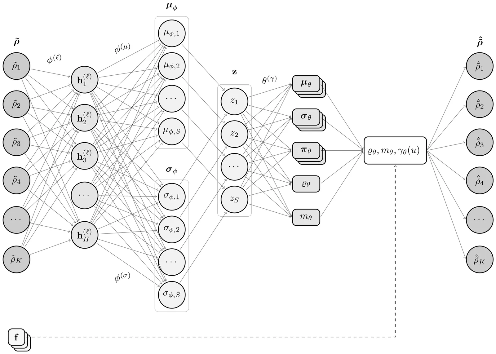
Probabilistic machine learning of relaxation time distributions in spectral induced polarization
Debye decomposition methods are widely used to interpret spectral induced polarization (SIP) data and to recover the relaxation time distribution (RTD) of geomaterials. However, SIP interpretation remains challenging for heterogeneous data sets because conventional decomposition methods treat each spectrum independently and provide limited uncertainty quantification. A probabilistic machine learning method is introduced to infer continuous RTD directly from complex resistivity spectra, using a combined laboratory and field data set comprising 140 SIP measurements of granular mixtures, rock cores, field surveys, and cementitious materials. The approach relies on a conditional variational autoencoder (CVAE) that performs decomposition at the data set level and learns a shared inverse mapping from complex resistivity spectra to probabilistic RTD expressed as Gaussian mixtures. The CVAE reproduces measured spectra with global errors below 0.53% and 0.45% over the full frequency range for the real and imaginary components, respectively. Dominant relaxation modes are recovered consistently, and both the total chargeability and the mean relaxation time show strong correlations with polarizable grain content and grain size, respectively, with coefficients of determination up to 0.95. Jacobian-based sensitivity analysis shows that the placement, width, and relative weighting of relaxation modes contribute to approximately 89% of the decomposition process. In contrast, the total chargeability contributes to 10% and the resistivity scaling parameter less than 1%. Latent variables learned by the CVAE organize SIP data into a structured space where sample populations naturally cluster without supervision. Compared to the chargeability and relaxation time domain, a two-dimensional projection of the latent variables improves the Davies--Bouldin clustering index by nearly a factor of three.
2603.13973Mar 2026
ViewPage 1 of 16