Atmospheric and Oceanic Physics
arXiv:physics.ao-ph
Atmospheric physics, climate science, ocean dynamics, weather modeling.
Atmospheric physics, climate science, ocean dynamics, weather modeling.
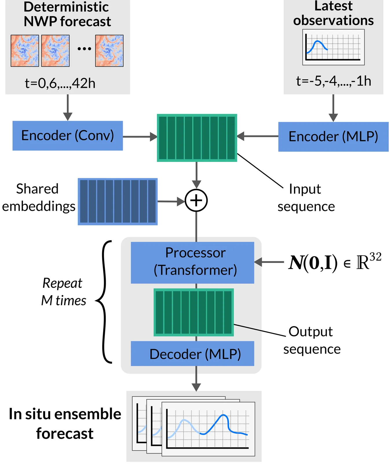
We propose Space-time in situ postprocessing (STIPP), a machine learning model that generates spatio-temporally consistent weather forecasts for a network of station locations. Gridded forecasts from classical numerical weather prediction or data-driven models often lack the necessary precision due to unresolved local effects. Typical statistical postprocessing methods correct these biases, but often degrade spatio-temporal correlation structures in doing so. Recent works based on generative modeling successfully improve spatial correlation structures but have to forecast every lead time independently. In contrast, STIPP makes joint spatio-temporal forecasts which have increased accuracy for surface temperature, wind, relative humidity and precipitation when compared to baseline methods. It makes hourly ensemble predictions given only a six-hourly deterministic forecast, blending the boundaries of postprocessing and temporal interpolation. By leveraging a multivariate proper scoring rule for training, STIPP contributes to ongoing work data-driven atmospheric models supervised only with distribution marginals.

Large data-driven physics models like DeepMind's weather model GraphCast have empirically succeeded in parameterizing time operators for complex dynamical systems with an accuracy reaching or in some cases exceeding that of traditional physics-based solvers. Unfortunately, how these data-driven models perform computations is largely unknown and whether their internal representations are interpretable or physically consistent is an open question. Here, we adapt tools from interpretability research in Large Language Models to analyze intermediate computational layers in GraphCast, leveraging sparse autoencoders to discover interpretable features in the neuron space of the model. We uncover distinct features on a wide range of length and time scales that correspond to tropical cyclones, atmospheric rivers, diurnal and seasonal behavior, large-scale precipitation patterns, specific geographical coding, and sea-ice extent, among others. We further demonstrate how the precise abstraction of these features can be probed via interventions on the prediction steps of the model. As a case study, we sparsely modify a feature corresponding to tropical cyclones in GraphCast and observe interpretable and physically consistent modifications to evolving hurricanes. Such methods offer a window into the black-box behavior of data-driven physics models and are a step towards realizing their potential as trustworthy predictors and scientifically valuable tools for discovery.
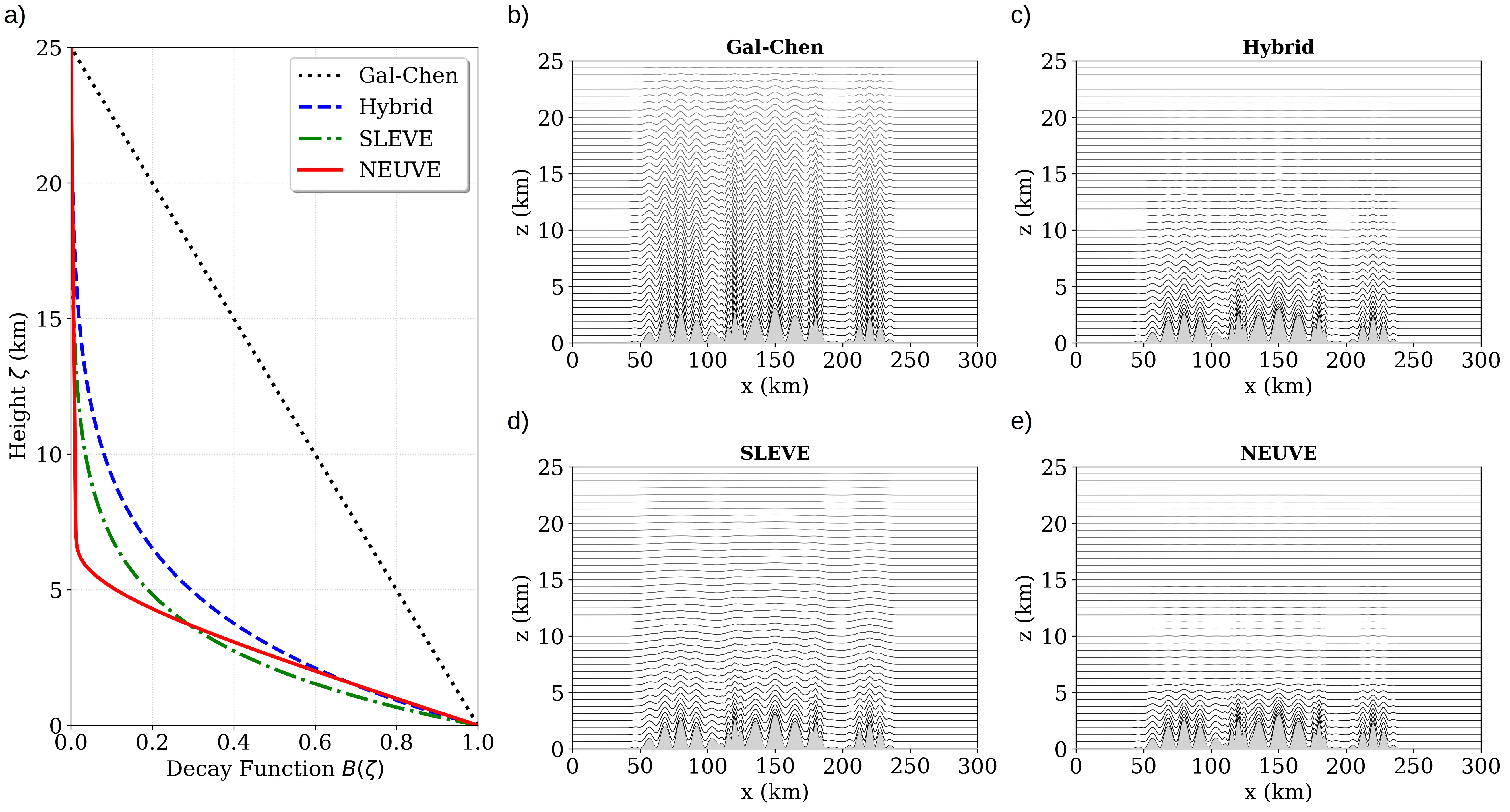
Terrain-following coordinates in atmospheric models often imprint their grid structure onto the solution, particularly over steep topography, where distorted coordinate layers can generate spurious horizontal and vertical motion. Standard formulations, such as hybrid or SLEVE coordinates, mitigate these errors by using analytic decay functions controlled by heuristic scale parameters that are typically tuned by hand and fixed a priori. In this work, we propose a framework to define a parametric vertical coordinate system as a learnable component within a differentiable dynamical core. We develop an end-to-end differentiable numerical solver for the two-dimensional non-hydrostatic Euler equations on an Arakawa C-grid, and introduce a NEUral Vertical Enhancement (NEUVE) terrain-following coordinate based on an integral transformed neural network that guarantees monotonicity. A key feature of our approach is the use of automatic differentiation to compute exact geometric metric terms, thereby eliminating truncation errors associated with finite-difference coordinate derivatives. By coupling simulation errors through the time integration to the parameterization, our formulation finds a grid structure optimized for both the underlying physics and numerics. Using several standard tests, we demonstrate that these learned coordinates reduce the mean squared error by a factor of 1.4 to 2 in non-linear statistical benchmarks, and eliminate spurious vertical velocity striations over steep topography.
We introduce WaveSim, a multi-scale similarity metric for the evaluation of spatial fields in weather and climate applications. WaveSim exploits wavelet transforms to decompose input fields into scale-specific wavelet coefficients. The metric is built by multiplying three orthogonal components derived from these coefficients: Magnitude, which quantifies similarities in the energy distribution of the coefficients, i.e., the intensity of the field; Displacement, which captures spatial shift by comparing the centers of mass of normalized energy distributions; and Structure, which assesses pattern organization independent of location and amplitude. Each component yields a scale-specific similarity score ranging from 0 (no similarity) to 1 (perfect similarity), which are then combined across scales to produce an overall similarity measure. We first evaluate WaveSim using synthetic test cases, applying controlled spatial and temporal perturbations to systematically assess its sensitivity and expected behavior. We then demonstrate its applicability to physically relevant case studies of key modes of climate variability in Earth System Models. Traditional point-wise metrics lack a mechanism for attributing errors to physical scales or modes of dissimilarity. By operating in the wavelet domain and decomposing the signal along independent axes, WaveSim bypasses these limitations and provides an interpretable and diagnostically rich framework for assessing similarity in complex fields. Additionally, the WaveSim framework allows users to place emphasis on a specific scale or component, and lends itself to user-specific model intercomparison, model evaluation, and calibration and training of forecasting systems. We provide a PyTorch-ready implementation of WaveSim, along with all evaluation scripts, at: https://github.com/gabrieleaccarino/wavesim.
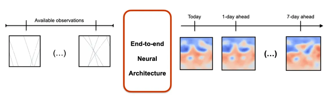
We present an end-to-end deep learning framework for short-term forecasting of global sea surface dynamics based on sparse satellite altimetry data. Building on two state-of-the-art architectures: U-Net and 4DVarNet, originally developed for image segmentation and spatiotemporal interpolation respectively, we adapt the models to forecast the sea level anomaly and sea surface currents over a 7-day horizon using sequences of sparse nadir altimeters observations. The model is trained on data from the GLORYS12 operational ocean reanalysis, with synthetic nadir sampling patterns applied to simulate realistic observational coverage. The forecasting task is formulated as a sequence-to-sequence mapping, with the input comprising partial sea level anomaly (SLA) snapshots and the target being the corresponding future full-field SLA maps. We evaluate model performance using (i) normalized root mean squared error (nRMSE), (ii) averaged effective resolution, (iii) percentage of correctly predicted velocities magnitudes and angles, and benchmark results against the operational Mercator Ocean forecast product. Results show that end-to-end neural forecasts outperform the baseline across all lead times, with particularly notable improvements in high variability regions. Our framework is developed within the OceanBench benchmarking initiative, promoting reproducibility and standardized evaluation in ocean machine learning. These results demonstrate the feasibility and potential of end-to-end neural forecasting models for operational oceanography, even in data-sparse conditions.
This paper documents a data set of UK rain radar image sequences for use in statistical modeling and machine learning methods for nowcasting. The main dataset contains 1,000 randomly sampled sequences of length 20 steps (15-minute increments) of 2D radar intensity fields of dimension 40x40 (at 5km spatial resolution). Spatially stratified sampling ensures spatial homogeneity despite removal of clear-sky cases by threshold-based truncation. For each radar sequence, additional atmospheric and geographic features are made available, including date, location, mean elevation, mean wind direction and speed and prevailing storm type. New R functions to extract data from the binary "Nimrod" radar data format are provided. A case study is presented to train and evaluate a simple convolutional neural network for radar nowcasting, including self-contained R code.
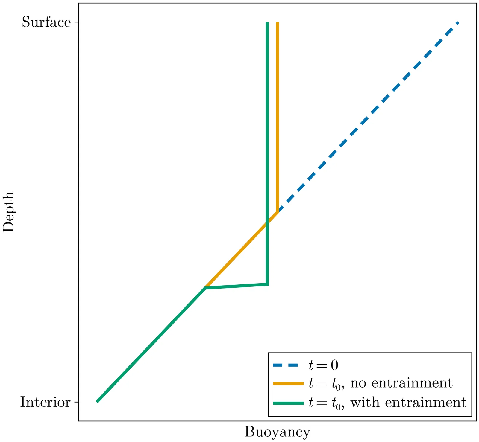
NORi is a machine-learned (ML) parameterization of ocean boundary layer turbulence that is physics-based and augmented with neural networks. NORi stands for neural ordinary differential equations (NODEs) Richardson number (Ri) closure. The physical parameterization is controlled by a Richardson number-dependent diffusivity and viscosity. The NODEs are trained to capture the entrainment through the base of the boundary layer, which cannot be represented with a local diffusive closure. The parameterization is trained using large-eddy simulations in an "a posteriori" fashion, where parameters are calibrated with a loss function that explicitly depends on the actual time-integrated variables of interest rather than the instantaneous subgrid fluxes, which are inherently noisy. NORi is designed for the realistic nonlinear equation of state of seawater and demonstrates excellent prediction and generalization capabilities in capturing entrainment dynamics under different convective strengths, oceanic background stratifications, rotation strengths, and surface wind forcings. NORi is numerically stable for at least 100 years of integration time in large-scale simulations, despite only being trained on 2-day horizons, and can be run with time steps as long as one hour. The highly expressive neural networks, combined with a physically-rigorous base closure, prove to be a robust paradigm for designing parameterizations for climate models where data requirements are drastically reduced, inference performance can be directly targeted and optimized, and numerical stability is implicitly encouraged during training.
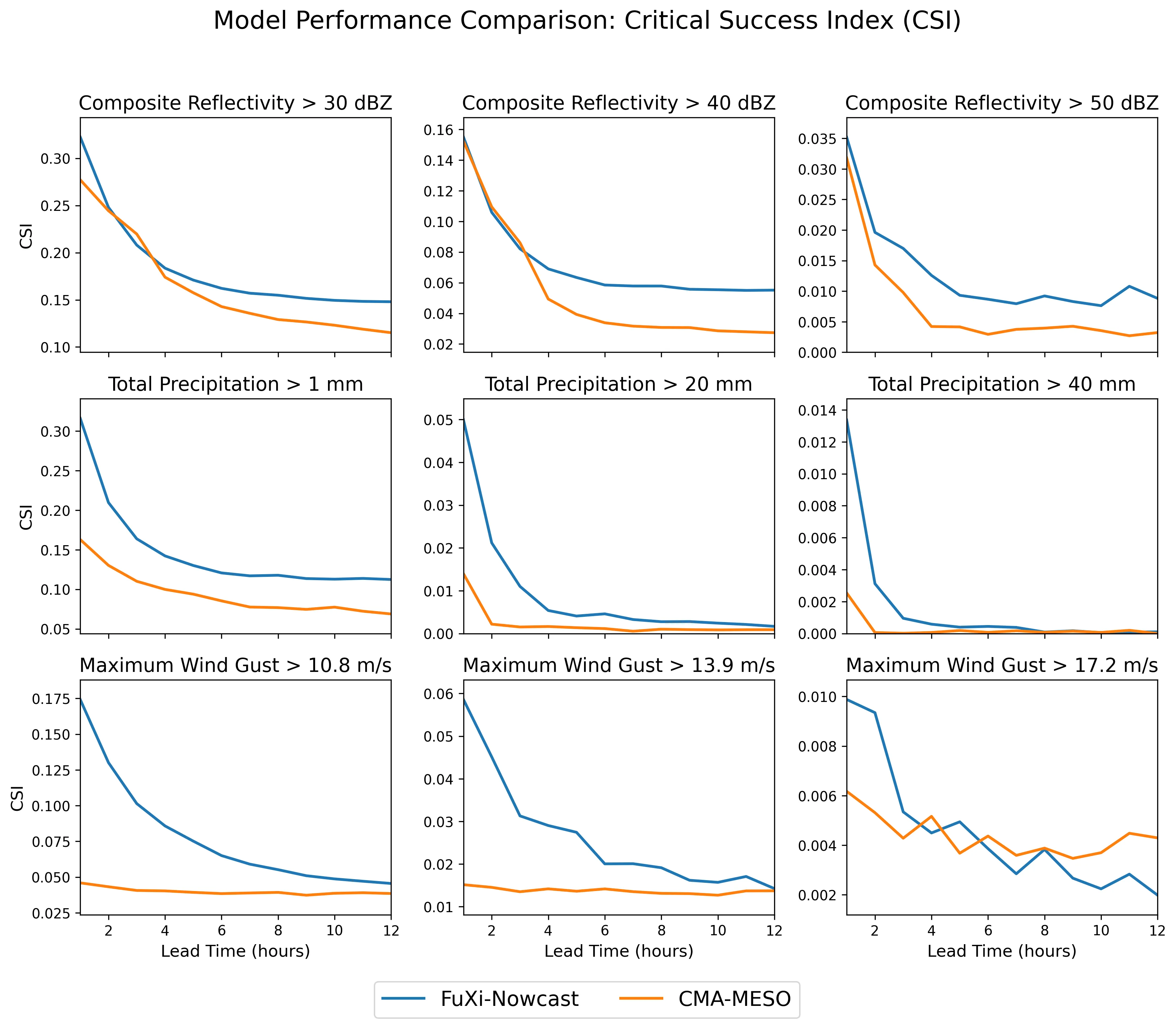
Accurate nowcasting of convective storms remains a major challenge for operational forecasting, particularly for convective initiation and the evolution of high-impact rainfall and strong winds. Here we present FuXi-Nowcast, a deep-learning system that jointly predicts composite radar reflectivity, surface precipitation, near-surface temperature, wind speed and wind gusts at 1-km resolution over eastern China. FuXi-Nowcast integrates multi-source observations, such as radar, surface stations and the High-Resolution Land Data Assimilation System (HRLDAS), with three-dimensional atmospheric fields from the machine-learning weather model FuXi-2.0 within a multi-task Swin-Transformer architecture. A convective signal enhancement module and distribution-aware hybrid loss functions are designed to preserve intense convective structures and mitigate the rapid intensity decay common in deep-learning nowcasts. FuXi-Nowcast surpasses the operational CMA-MESO 3-km numerical model in Critical Success Index for reflectivity, precipitation and wind gusts across thresholds and lead times up to 12 h, with the largest gains for heavy rainfall. Case studies further show that FuXi-Nowcast more accurately captures the timing, location and structure of convective initiation and subsequent evolution of convection. These results demonstrate that coupling three-dimensional machine-learning forecasts with high-resolution observations can provide multi-hazard, long-lead nowcasts that outperforms current operational systems.
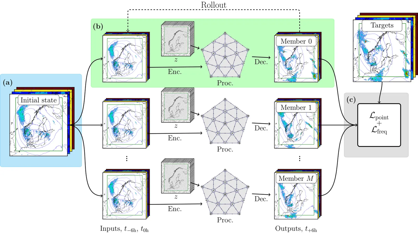
We present a probabilistic data-driven weather model capable of providing an ensemble of high spatial resolution realizations of 87 variables at arbitrary forecast length and ensemble size. The model uses a stretched grid, dedicating 2.5 km resolution to a region of interest, and 31 km resolution elsewhere. Based on a stochastic encoder-decoder architecture, the model is trained using a loss function based on the Continuous Ranked Probability Score (CRPS) evaluated point-wise in real and spectral space. The spectral loss components is shown to be necessary to create fields that are spatially coherent. The model is compared to high-resolution operational numerical weather prediction forecasts from the MetCoOp Ensemble Prediction System (MEPS), showing competitive forecasts when evaluated against observations from surface weather stations. The model produced fields that are more spatially coherent than mean squared error based models and CRPS based models without the spectral component in the loss.
Machine learning (ML) has shown significant promise in studying complex geophysical dynamical systems, including turbulence and climate processes. Such systems often display sensitive dependence on initial conditions, reflected in positive Lyapunov exponents, where even small perturbations in short-term forecasts can lead to large deviations in long-term outcomes. Thus, meaningful inference requires not only accurate short-term predictions, but also consistency with the system's long-term attractor that is captured by the marginal distribution of state variables. Existing approaches attempt to address this challenge by incorporating spatial and temporal dependence, but these strategies become impractical when data are extremely sparse. In this work, we show that prior knowledge of marginal distributions offers valuable complementary information to short-term observations, motivating a distribution-informed learning framework. We introduce a calibration algorithm based on normalization and the Kernelized Stein Discrepancy (KSD) to enhance ML predictions. The method here employs KSD within a reproducing kernel Hilbert space to calibrate model outputs, improving their fidelity to known physical distributions. This not only sharpens pointwise predictions but also enforces consistency with non-local statistical structures rooted in physical principles. Through synthetic experiments-spanning offline climatological CO2 fluxes and online quasi-geostrophic flow simulations-we demonstrate the robustness and broad utility of the proposed framework.

Predicting ocean wave behavior is challenging due to the difficulty in choosing suitable numerical models among many with varying capabilities. This review examines the development and performance of numerical wave models in coastal engineering and oceanography, focusing on the difference between phase-averaged spectral models and phase-resolving models. We evaluate the formulation, governing equations, and methods of widely used third-generation phase-averaged spectral models (SWAN, WAVEWATCH III, MIKE 21 SW, TOMAWAC, and WAM) alongside advanced phase-resolving models (FUNWAVE, SWASH, COULWAVE, and NHWAVE) that employ Boussinesq-type equations and non-hydrostatic formulations. The review begins with early parameterized models and progresses to contemporary third-generation models, which solve the wave action conservation equation with few spectral constraints. A comparison of the models' efficiency, accuracy in nearshore conditions, ability to resolve nonlinear wave-wave interaction, simulate wave breaking, diffraction, and wave-current interactions is provided. Applications in operational forecasting, extreme event simulation, coastal structure design, and assessing climate change impacts are discussed. The validation of these models and the statistical metrics and intercomparison studies used are addressed. A discussion of the limitations in computational scalability, physics parameterization, and model coupling is provided, along with emerging trends in high-resolution modeling and hybrid models. This review guides researchers in evaluating which models to use in coastal and oceanographic research.
Subgrid machine-learning (ML) parameterizations have the potential to introduce a new generation of climate models that incorporate the effects of higher-resolution physics without incurring the prohibitive computational cost associated with more explicit physics-based simulations. However, important issues, ranging from online instability to inconsistent online performance, have limited their operational use for long-term climate projections. To more rapidly drive progress in solving these issues, domain scientists and machine learning researchers opened up the offline aspect of this problem to the broader machine learning and data science community with the release of ClimSim, a NeurIPS Datasets and Benchmarks publication, and an associated Kaggle competition. This paper reports on the downstream results of the Kaggle competition by coupling emulators inspired by the winning teams' architectures to an interactive climate model (including full cloud microphysics, a regime historically prone to online instability) and systematically evaluating their online performance. Our results demonstrate that online stability in the low-resolution, real-geography setting is reproducible across multiple diverse architectures, which we consider a key milestone. All tested architectures exhibit strikingly similar offline and online biases, though their responses to architecture-agnostic design choices (e.g., expanding the list of input variables) can differ significantly. Multiple Kaggle-inspired architectures achieve state-of-the-art (SOTA) results on certain metrics such as zonal mean bias patterns and global RMSE, indicating that crowdsourcing the essence of the offline problem is one path to improving online performance in hybrid physics-AI climate simulation.
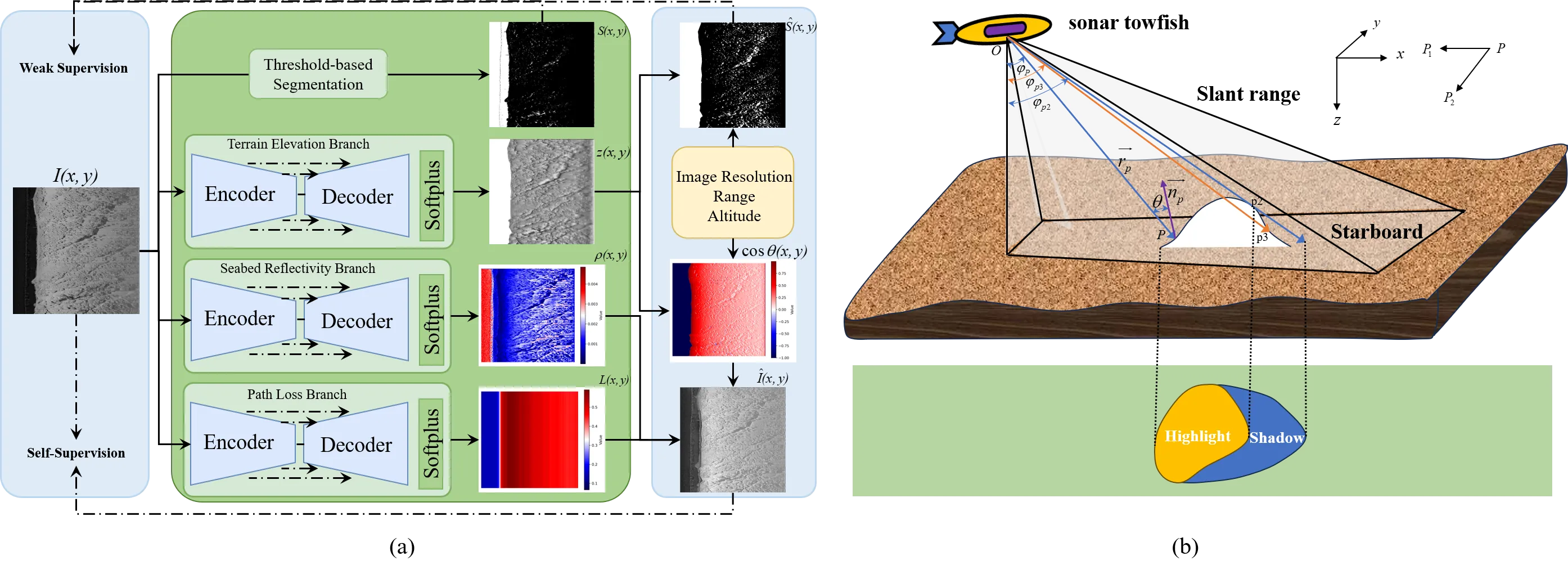
Side-scan sonar (SSS) imagery is widely used for seafloor mapping and underwater remote sensing, yet the measured intensity is strongly influenced by seabed reflectivity, terrain elevation, and acoustic path loss. This entanglement makes the imagery highly view-dependent and reduces the robustness of downstream analysis. In this letter, we present PhysDNet, a physics-guided multi-branch network that decouples SSS images into three interpretable fields: seabed reflectivity, terrain elevation, and propagation loss. By embedding the Lambertian reflection model, PhysDNet reconstructs sonar intensity from these components, enabling self-supervised training without ground-truth annotations. Experiments show that the decomposed representations preserve stable geological structures, capture physically consistent illumination and attenuation, and produce reliable shadow maps. These findings demonstrate that physics-guided decomposition provides a stable and interpretable domain for SSS analysis, improving both physical consistency and downstream tasks such as registration and shadow interpretation.
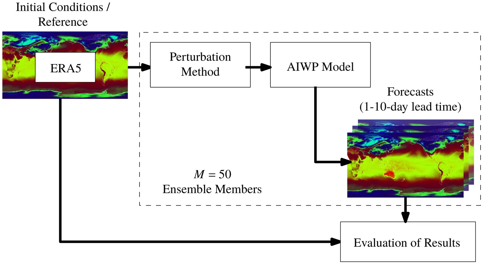
Accurate prediction of extreme weather events remains a major challenge for artificial intelligence based weather prediction systems. While deterministic models such as FuXi, GraphCast, and SFNO have achieved competitive forecast skill relative to numerical weather prediction, their ability to represent uncertainty and capture extremes is still limited. This study investigates how state of the art deterministic artificial intelligence based models respond to initial-condition perturbations and evaluates the resulting ensembles in forecasting extremes. Using three perturbation strategies (Gaussian noise, Hemispheric Centered Bred Vectors, and Huge Ensembles), we generate 50 member ensembles for two major events in August 2022: the Pakistan floods and the China heatwave. Ensemble skill is assessed against ERA5 and compared with IFS ENS and the probabilistic AIFSENS model using deterministic and probabilistic metrics. Results show that flow dependent perturbations produce the most realistic ensemble spread and highest probabilistic skill, narrowing but not closing the performance gap with numerical weather prediction ensembles. Across variables, artificial intelligence based weather models capture temperature extremes more effectively than precipitation. These findings demonstrate that input perturbations can extend deterministic models toward probabilistic forecasting, paving the way for approaches that combine flow dependent perturbations with generative or latent-space uncertainty modeling for reliable artificial intelligence-driven early warning systems.
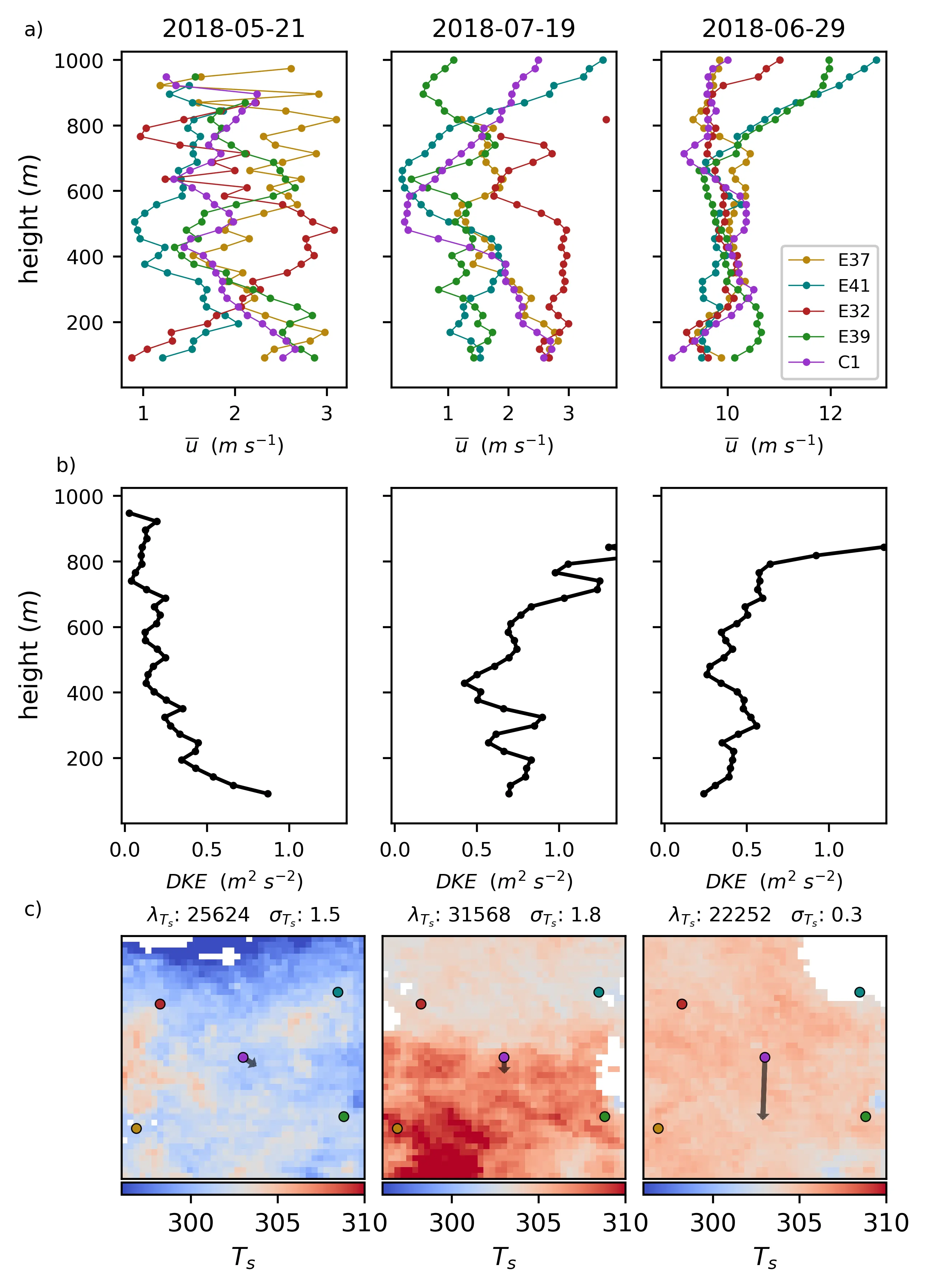
Surface heterogeneity, particularly complex patterns of surface heating, significantly influences mesoscale atmospheric flows, yet observational constraints and modeling limitations have hindered comprehensive understanding and model parameterization. This study introduces a framework combining satellite remote sensing and Doppler LiDAR to observationally evaluate heterogeneity-driven mesoscale flows in the atmospheric boundary layer. We quantify surface heterogeneity using metrics derived from GOES land surface temperature fields, and assess atmospheric impact through the Dispersive Kinetic Energy (DKE) calculated from a network of Doppler LiDAR profiles at the Southern Great Plains (SGP) Atmospheric Radiation Measurement (ARM) site. Results demonstrate that DKE and its ratio to the Mean Kinetic Energy (MKE) serve as effective indicators of heterogeneity driven flows, including breezes and circulations. The DKE and DKE ratio are correlated with metrics for surface heterogeneity, including the spatial correlation lengthscale, the spatial standard deviation, and the orientation of the surface heating gradient relative to the wind. The correlation becomes stronger when other flows that would affect DKE, including deep convection, low level jets, and storm fronts, are accounted for. Large Eddy Simulations contextualize the findings and validate the metric's behavior, showing general agreement with expectations from prior literature. Simulations also illustrate the sensitivity to configuration of LiDAR networks using virtual LiDAR sites, indicating that even smaller networks can be used effectively. This approach offers a scalable, observationally grounded method to explore heterogeneity-driven flows, advancing understanding of land-atmosphere interactions as well as efforts to parameterize these dynamics in climate and weather prediction models.
Traditional methods for enhancing tropical cyclone (TC) intensity from climate model outputs or projections have primarily relied on either dynamical or statistical downscaling. With recent advances in deep learning (DL) techniques, a natural question is whether DL can provide an alternative approach for improving TC intensity estimation from climate data. Using a common DL architecture based on convolutional neural networks (CNN) and selecting a set of key environmental features, we show that both TC intensity and structure can be effectively downscaled from climate reanalysis data as compared to common vortex detection methods, even when applied to coarse-resolution (0.5-degree) data. Our results thus highlight that TC intensity and structure are governed not only by its internal dynamics but also by local environments during TC development, for which DL models can learn and capture beyond the potential intensity framework. The performance of our DL model depends on several factors such as data sampling strategy, season, or the stage of TC development, with root-mean-square errors ranging from 3-9 ms$^{-1}$ for maximum 10 m wind and 10-20 hPa for minimum central pressure. Although these errors are better than direct vortex detection methods, their wide ranges also suggest that 0.5-degree resolution climate data may contain limited TC information for DL models to learn from, regardless of model optimizations or architectures. Possible improvements and challenges in addressing the lack of fine-scale TC information in coarse resolution climate reanalysis datasets will be discussed.
In this study, we improve a neural network (NN) parameterization of deep convection in the global atmosphere model ARP-GEM. To take into account the sporadic nature of convection, we develop a NN parameterization that includes a triggering mechanism that can detect whether deep convection is active or not within a grid-cell. This new data-driven parameterization outperforms the existing NN parameterization in present climate when replacing the original deep convection scheme of ARP-GEM. Online simulations with the NN parameterization run without stability issues. Then, this NN parameterization is evaluated online in a warmer climate. We confirm that using relative humidity instead of the specific total humidity as input for the NN (trained with present data) improves the performance and generalization in warmer climate. Finally, we perform the training of the NN parameterization with data from a warmer climate and this configuration get similar results when used in simulations in present or warmer climates.
Arctic sea ice is rapidly retreating due to global warming, and emerging evidence suggests that the rate of decline may have been underestimated. A key factor contributing to this underestimation is the coarse resolution of current climate models, which fail to accurately represent eddy floe interactions, climate extremes, and other critical small scale processes. Here, we elucidate the roles of these dynamics in accelerating sea ice melt and emphasize the need for higher resolution models to improve projections of Arctic sea ice.
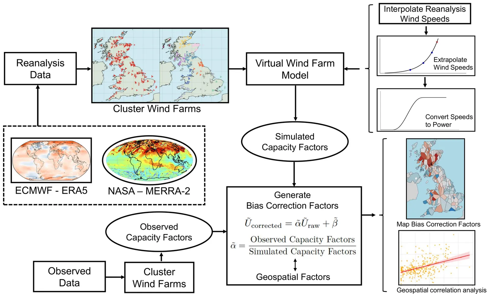
Reanalysis datasets have become indispensable tools for wind resource assessment and wind power simulation, offering long-term and spatially continuous wind fields across large regions. However, they inherently contain systematic wind speed biases arising from various factors, including simplified physical parameterizations, observational uncertainties, and limited spatial resolution. Among these, low spatial resolution poses a particular challenge for capturing local variability accurately. Whereas prevailing industry practice generally relies on either no bias correction or coarse, nationally uniform adjustments, we extend and thoroughly analyse a recently proposed spatially resolved, cluster-based bias correction framework. This approach is designed to better account for local heterogeneity and is applied to 319 wind farms across the United Kingdom to evaluate its effectiveness. Results show that this method reduced monthly wind power simulation errors by more than 32% compared to the uncorrected ERA5 reanalysis dataset. The method is further applied to the MERRA-2 dataset for comparative evaluation, demonstrating its effectiveness and robustness for different reanalysis products. In contrast to prior studies, which rarely quantify the influence of topography on reanalysis biases, this research presents a detailed spatial mapping of bias correction factors across the UK. The analysis reveals that for wind energy applications, ERA5 wind speed errors exhibit strong spatial variability, with the most significant underestimations in the Scottish Highlands and mountainous areas of Wales. These findings highlight the importance of explicitly accounting for geographic variability when correcting reanalysis wind speeds, and provide new insights into region-specific bias patterns relevant for high-resolution wind energy modelling.
Consistency relations of internal gravity waves (IGWs) describe ratios of cross-spectral quantities as functions of frequency. It has been a common practice to evaluate the measured or simulated signals (e.g., time series of velocity, density, etc.) against the consistency relations, as a way to determine whether an oceanic field of interest is comprised of IGWs. One such study is carried out in Nelson et al. (JGR Oceans, 125(5), 2020, e2019JC015974), which certifies that the ocean interior field in a numerical simulation of a region southwest of Hawaii is dominated by IGWs, through evaluating the consistency relations derived from time series at a depth of 620 m. However, we find that when the same procedure is applied at greater depths (e.g., 2362 m, 3062 m, and 4987 m), a clear deviation of the simulated signal from the classical consistency relations is observed. In this paper, we identify the reason for the unexpected deviation and show that it is a general phenomenon due to interference of low vertical modes under the reflection by the ocean bottom. We further derive a new set of formulae to characterize the consistency relations of these low modes and validate these formulae using model output.
Side-scan sonar (SSS) imagery is widely used for seafloor mapping and underwater remote sensing, yet the measured intensity is strongly influenced by seabed reflectivity, terrain elevation, and acoustic path loss. This entanglement makes the imagery highly view-dependent and reduces the robustness of downstream analysis. In this letter, we present PhysDNet, a physics-guided multi-branch network that decouples SSS images into three interpretable fields: seabed reflectivity, terrain elevation, and propagation loss. By embedding the Lambertian reflection model, PhysDNet reconstructs sonar intensity from these components, enabling self-supervised training without ground-truth annotations. Experiments show that the decomposed representations preserve stable geological structures, capture physically consistent illumination and attenuation, and produce reliable shadow maps. These findings demonstrate that physics-guided decomposition provides a stable and interpretable domain for SSS analysis, improving both physical consistency and downstream tasks such as registration and shadow interpretation.
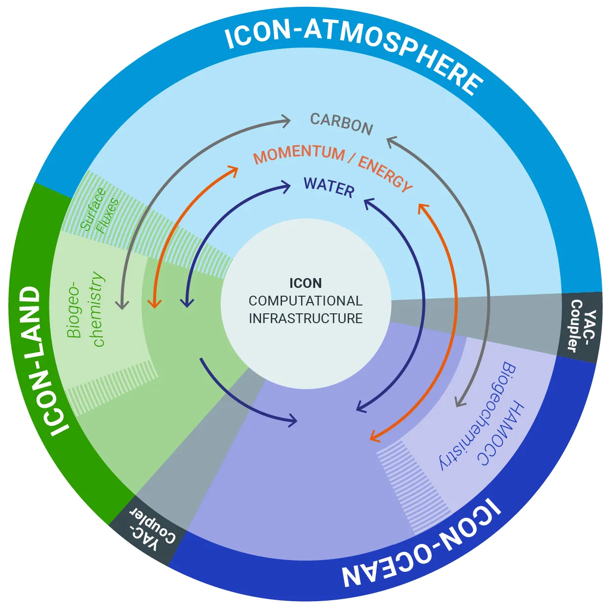
We present the first-ever global simulation of the full Earth system at 1.25 km grid spacing, achieving highest time compression with an unseen number of degrees of freedom. Our model captures the flow of energy, water, and carbon through key components of the Earth system: atmosphere, ocean, and land. To achieve this landmark simulation, we harness the power of 8192 GPUs on Alps and 20480 GPUs on JUPITER, two of the world's largest GH200 superchip installations. We use both the Grace CPUs and Hopper GPUs by carefully balancing Earth's components in a heterogeneous setup and optimizing acceleration techniques available in ICON's codebase. We show how separation of concerns can reduce the code complexity by half while increasing performance and portability. Our achieved time compression of 145.7 simulated days per day enables long studies including full interactions in the Earth system and even outperforms earlier atmosphere-only simulations at a similar resolution.
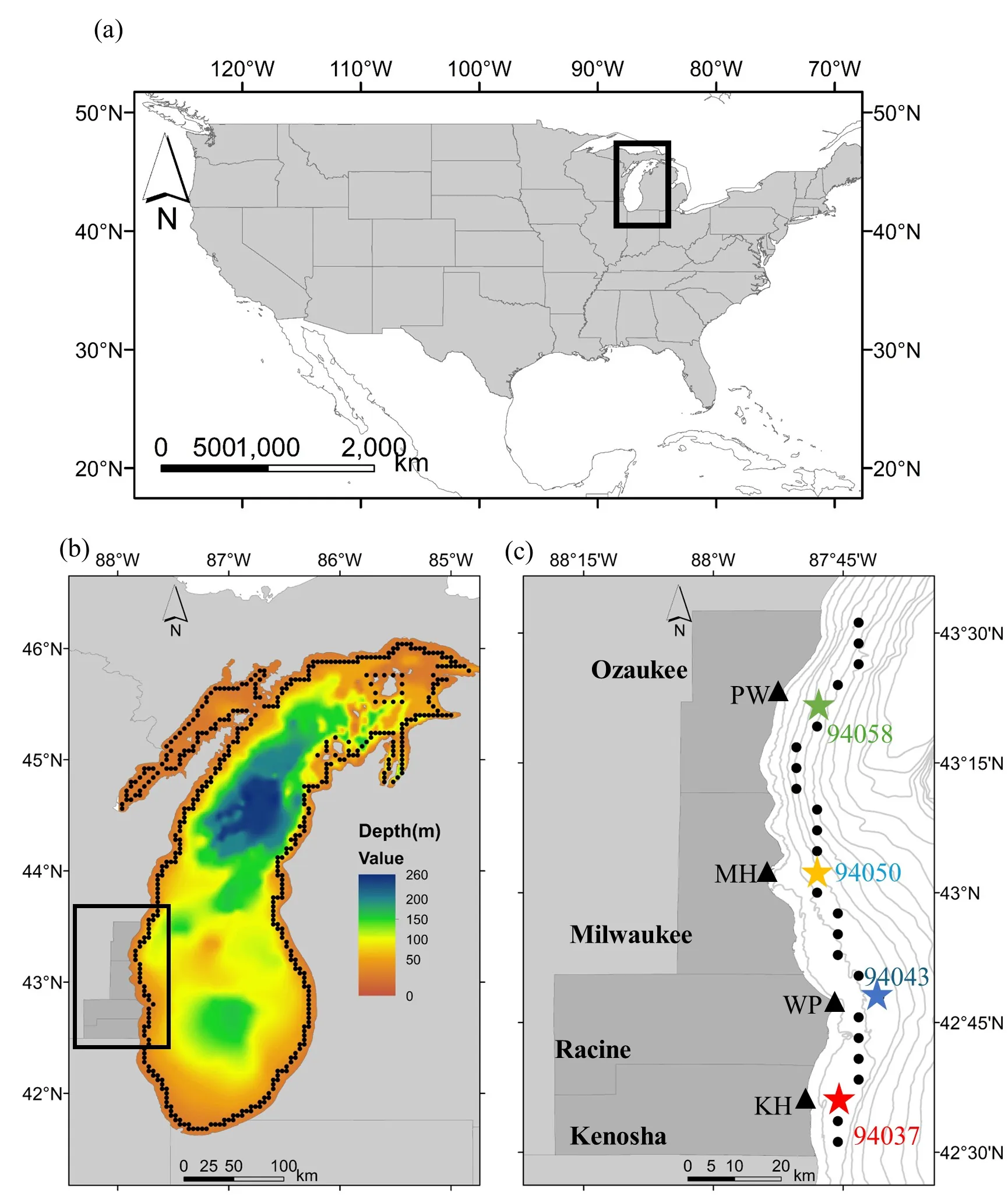
Wave directionality plays a critical role in shaping coastal conditions and influencing local livelihoods, underscoring the importance of conducting detailed analyses. This study examines directional wave climate along the southwestern coast of Lake Michigan from 1979 to 2023 using the Directional Wave Entropy (DWE). Directionality was characterized in terms of inter-annual trends, monthly patterns, spatial variation, and extreme wave conditions. Overall, results exhibited a strong bi-directionality, with dominant northern and southern wave systems along the coast of our study site. A few annual trends for the inter-annual wave climate were observed, and there is a clear seasonal variation such that bi-directionality increases in the summer and winter seasons. As for spatial variation of wave directionality, all locations in the study sites presented a bi-directional wave climate. The two dominant directions of wave directionality: northern and southern mean significant wave heights were also characterized in all locations of study sites as 0.566 and 0.563 meters. Furthermore, the extreme wave heights in the northern direction are significantly greater than the extreme waves in the southern direction. In summary, these findings suggest the importance of wave directionality on coastal structural design and coastal morphology management along the coast of our study site.
This review synthesizes recent advancements in understanding tipping points and cascading transitions within the Earth system, framing them through the lens of nonlinear dynamics and complexity science. It outlines the fundamental concepts of tipping elements, large-scale subsystems like the Atlantic Meridional Overturning Circulation and the Amazon rainforest, and classifies tipping mechanisms into bifurcation-, noise-, and rate-induced types. The article critically evaluates methods for detecting early-warning signals, particularly those based on critical slowing down, while also acknowledging their limitations and the promise of non-conventional indicators. Furthermore, we explore the significant risk of cascading failures between interacting tipping elements, often modeled using conceptual network models. This shows that such interactions can substantially increase systemic risk under global warming. The review concludes by outlining key challenges related to data limitations and methodological robustness, and emphasizes the promising role of artificial intelligence and complex network science in advancing prediction and risk assessment of Earth system tipping dynamics.
The objective of this paper is twofold. First, it documents the second version of the global atmospheric model ARP-GEM and its calibration at kilometer-scale resolution. The model is currently able to run simulations at a resolution of up to 1.3 km. Second, this paper focus on multi-year global atmospheric simulations at a 2.6 km resolution with and without parameterized convection and associated calibration. Simulations without deep convection tend to be similar to those with infinite, or at least large, entrainment values. Consistently, entrainment and detrainment are used as primary drivers for the gradual reduction of convection as resolution increases. The results indicate that, with this hydrostatic model, parameterized convection still plays a significant role in the correct representation of the mean state at the kilometer scale. Additionally, they suggest some added value of high resolution in representing climate variability. However, a compromise between the adequate representation of the mean state and variability is necessary, as both are differently favored by the degree of parameterized convection. Finally, it is likely that even higher resolutions are necessary to achieve an unequivocal added value.
Over the past decade, it has become clear that the radiative response to surface temperature change depends on the spatially varying structure in the temperature field, a phenomenon known as the "pattern effect". The pattern effect is commonly estimated from dedicated climate model simulations forced with local surface temperatures patches (Green's function experiments). Green's function experiments capture causal influences from temperature perturbations, but are computationally expensive to run. Recently, however, several methods have been proposed that estimate the pattern effect through statistical means. These methods can accurately predict the radiative response to temperature variations in climate model simulations. The goal of this paper is to compare methods used to quantify the pattern effect. We apply each method to the same prediction task and discuss its advantages and disadvantages. Most methods indicate large negative feedbacks over the western Pacific. Over other regions, the methods frequently disagree on feedback sign and spatial homogeneity. While all methods yield similar predictions of the global radiative response to surface temperature variations driven by internal variability, they produce very different predictions from the patterns of surface temperature change in simulations forced with increasing CO2 concentrations. We discuss reasons for the discrepancies between methods and recommend paths towards using them in the future to enhance physical understanding of the pattern effect.

The Data Assimilation (DA) community has been developing various diagnostics to understand the importance of the observing system in accurately forecasting the weather. They usually rely on the ability to compute the derivatives of the physical model output with respect to its initial condition. For example, the Forecast Sensitivity-based Observation Impact (FSOI) estimates the impact on the forecast error of each observation processed in the DA system. This paper presents how these DA diagnostic tools are transferred to Machine Learning (ML) models, as their derivatives are readily available through automatic differentiation. We specifically explore the interpretability and explainability of the observation-driven GraphDOP model developed at the European Centre for Medium-Range Weather Forecasts (ECMWF). The interpretability study demonstrates the effectiveness of GraphDOP's sliding attention window to learn the meteorological features present in the observation datasets and to learn the spatial relationships between different regions. Making these relationships more transparent confirms that GraphDOP captures real, physically meaningful processes, such as the movement of storm systems. The explainability of GraphDOP is explored by applying the FSOI tool to study the impact of the different observations on the forecast error. This inspection reveals that GraphDOP creates an internal representation of the Earth system by combining the information from conventional and satellite observations.
Assessing the frequency and intensity of extreme weather events, and understanding how climate change affects them, is crucial for developing effective adaptation and mitigation strategies. However, observational datasets are too short and physics-based global climate models (GCMs) are too computationally expensive to obtain robust statistics for the rarest, yet most impactful, extreme events. AI-based emulators have shown promise for predictions at weather and even climate timescales, but they struggle on extreme events with few or no examples in their training dataset. Rare event sampling (RES) algorithms have previously demonstrated success for some extreme events, but their performance depends critically on a hard-to-identify "score function", which guides efficient sampling by a GCM. Here, we develop a novel algorithm, AI+RES, which uses ensemble forecasts of an AI weather emulator as the score function to guide highly efficient resampling of the GCM and generate robust (physics-based) extreme weather statistics and associated dynamics at 30-300x lower cost. We demonstrate AI+RES on mid-latitude heatwaves, a challenging test case requiring a score function with predictive skill many days in advance. AI+RES, which synergistically integrates AI, RES, and GCMs, offers a powerful, scalable tool for studying extreme events in climate science, as well as other disciplines in science and engineering where rare events and AI emulators are active areas of research.
The global ocean model NEMO is run in a series of stand-alone configurations (2015-2022) to investigate the potential for improving global medium-range storm surge forecasts by including the inverse barometer effect. Here, we compare a control experiment, where the inverse barometer effect was not included, against a run dynamically forced with mean sea level pressure. In the control experiment, the inverse barometer effect was then calculated diagnostically and added to the ocean model sea surface elevation, resulting in a total of three experiments to investigate. We compare against the global GESLA3 water level data set and find that the inclusion of the inverse barometer effect reduces the root-mean-square error by $\sim 1~cm$ on average. When we mask out all data where the observed storm surge is less than $\pm1$ or $\pm2$ standard deviations, including the inverse barometer effect reduces the RMS error by $4-5$ cm. While both methods reduce water level errors, there are regional differences in their performance. The run with dynamical pressure forcing is seen to perform slightly better than diagnostically adding the inverse barometer effect in enclosed basins such as the Baltic Sea. Finally, an ensemble forecast experiment with the Integrated Forecast System of the European Centre for Medium-range Weather Forecasts demonstrates that when the diagnostic inverse barometer effect is included for a severe storm surge event in the North Sea (Storm Xaver, December 2013), the ensemble spread of water level provides a stronger and earlier indication of the observed maximum surge level than the when the effect is excluded.
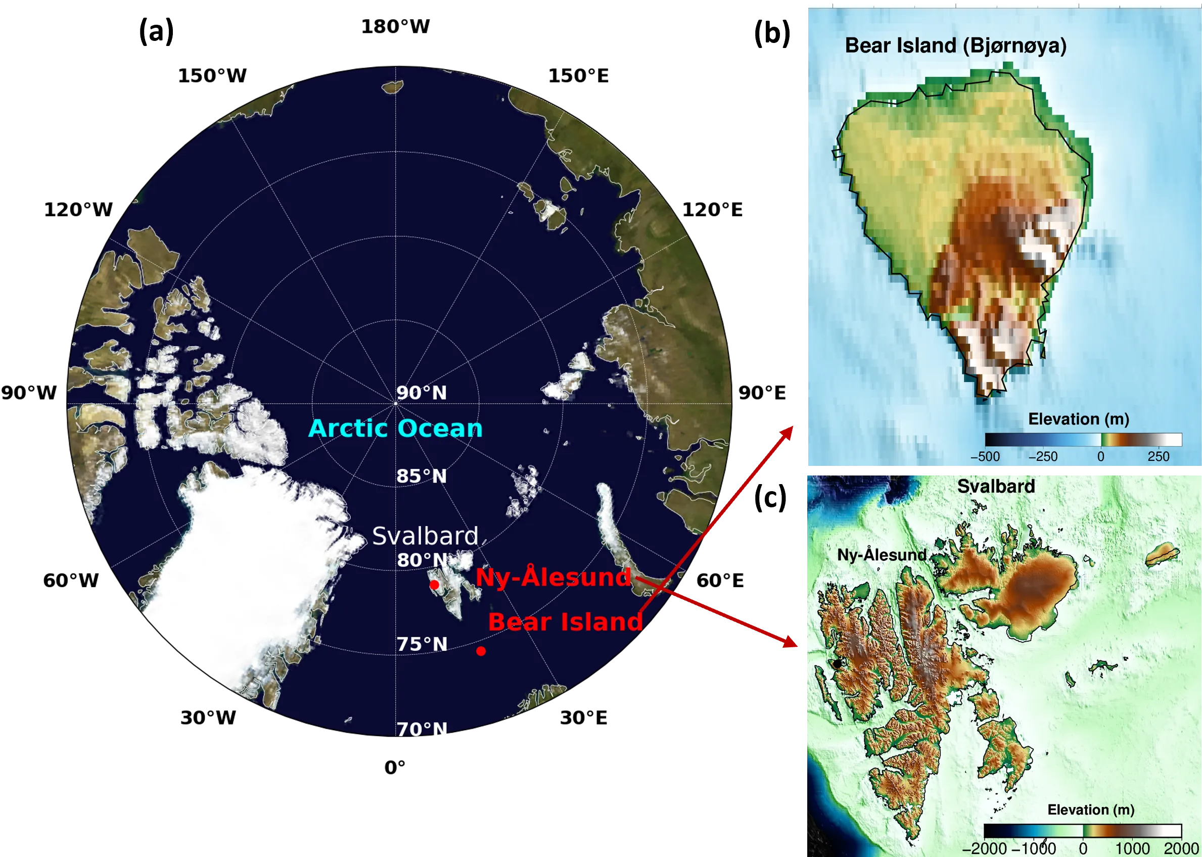
Understanding and forecasting precipitation events in the Arctic maritime environments, such as Bear Island and Ny-Ålesund, is crucial for assessing climate risk and developing early warning systems in vulnerable marine regions. This study proposes a probabilistic machine learning framework for modeling and predicting the dynamics and severity of precipitation. We begin by analyzing the scale-dependent relationships between precipitation and key atmospheric drivers (e.g., temperature, relative humidity, cloud cover, and air pressure) using wavelet coherence, which captures localized dependencies across time and frequency domains. To assess joint causal influences, we employ Synergistic-Unique-Redundant Decomposition, which quantifies the impact of interaction effects among each variable on future precipitation dynamics. These insights inform the development of data-driven forecasting models that incorporate both historical precipitation and causal climate drivers. To account for uncertainty, we employ the conformal prediction method, which enables the generation of calibrated non-parametric prediction intervals. Our results underscore the importance of utilizing a comprehensive framework that combines causal analysis with probabilistic forecasting to enhance the reliability and interpretability of precipitation predictions in Arctic marine environments.
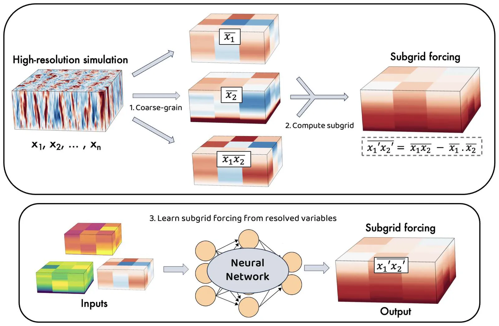
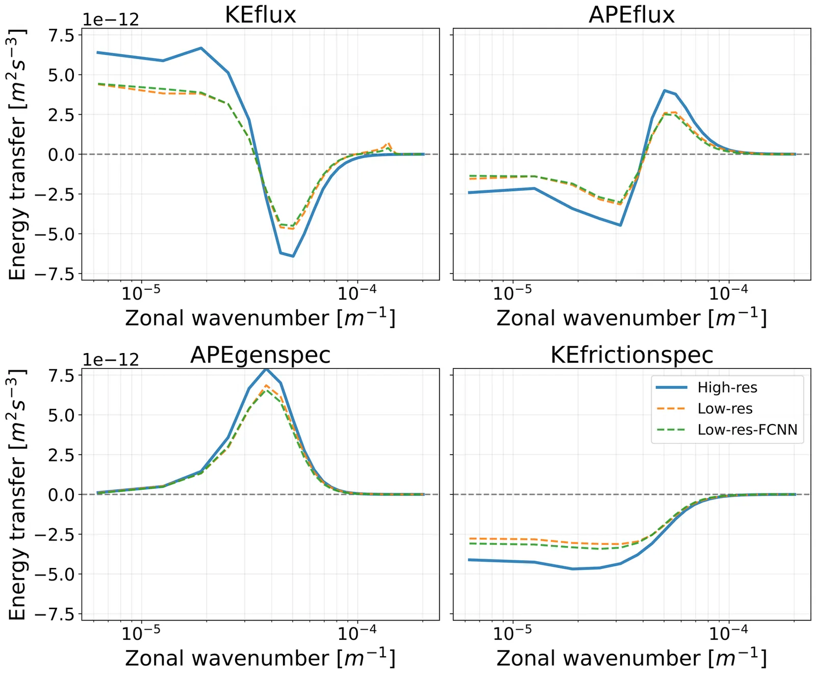
Climate simulations, at all grid resolutions, rely on approximations that encapsulate the forcing due to unresolved processes on resolved variables, known as parameterizations. Parameterizations often lead to inaccuracies in climate models, with significant biases in the physics of key climate phenomena. Advances in artificial intelligence (AI) are now directly enabling the learning of unresolved processes from data to improve the physics of climate simulations. Here, we introduce a flexible framework for developing and implementing physics- and scale-aware machine learning parameterizations within climate models. We focus on the ocean and sea-ice components of a state-of-the-art climate model by implementing a spectrum of data-driven parameterizations, ranging from complex deep learning models to more interpretable equation-based models. Our results showcase the viability of AI-driven parameterizations in operational models, advancing the capabilities of a new generation of hybrid simulations, and include prototypes of fully coupled atmosphere-ocean-sea-ice hybrid simulations. The tools developed are open source, accessible, and available to all.

It is tested whether past abrupt climate changes support the validity of statistical early-warning signals (EWS) as predictor of future climate tipping points. EWS are expected increases in amplitude and correlation of fluctuations driven by noise. This is a symptom of critical slowing down (CSD), where a system's recovery from an external perturbation becomes slower as a tipping point (represented by a bifurcation) is approached. EWS are a simple, indirect measure of CSD, but subject to assumptions on the noise process and measurement stationarity that are hard to verify. In this work the existence of CSD before the Dansgaard-Oeschger (DO) events of the last glacial period is directly tested by inferring the climate's recovery from large volcanic eruptions. By averaging over hundreds of eruptions, a well-defined, stationary perturbation is constructed and the average climate response is measured by eight ice core proxies. As the abrupt DO warming transitions are approached, the climate response to eruptions remains the same, indicating no CSD. For the abrupt DO cooling transitions, however, some key proxies show evidence of larger climate response and slower recovery as the transitions are approached. By comparison, almost all proxies show statistical EWS before cooling and warming transitions, but with only weak confidence for the warming transitions. There is thus qualitative agreement of CSD and EWS, in that the evidence for bifurcation precursors is larger for the cooling transitions. However, the discrepancy that many proxies show EWS but no direct CSD (and vice versa) highlights that statistical EWS in individual observables need to be interpreted with care.
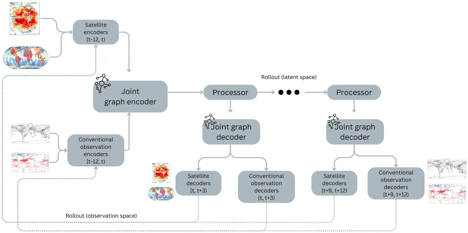
Interactions between different components of the Earth System (e.g. ocean, atmosphere, land and cryosphere) are a crucial driver of global weather patterns. Modern Numerical Weather Prediction (NWP) systems typically run separate models of the different components, explicitly coupled across their interfaces to additionally model exchanges between the different components. Accurately representing these coupled interactions remains a major scientific and technical challenge of weather forecasting. GraphDOP is a graph-based machine learning model that learns to forecast weather directly from raw satellite and in-situ observations, without reliance on reanalysis products or traditional physics-based NWP models. GraphDOP simultaneously embeds information from diverse observation sources spanning the full Earth system into a shared latent space. This enables predictions that implicitly capture cross-domain interactions in a single model without the need for any explicit coupling. Here we present a selection of case studies which illustrate the capability of GraphDOP to forecast events where coupled processes play a particularly key role. These include rapid sea-ice freezing in the Arctic, mixing-induced ocean surface cooling during Hurricane Ian and the severe European heat wave of 2022. The results suggest that learning directly from Earth System observations can successfully characterise and propagate cross-component interactions, offering a promising path towards physically consistent end-to-end data-driven Earth System prediction with a single model.
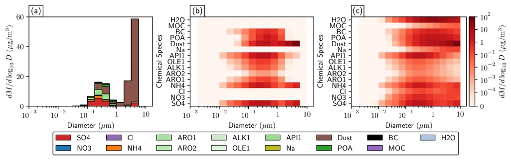
Aerosol-cloud--radiation interactions remain among the most uncertain components of the Earth's climate system, in partdue to the high dimensionality of aerosol state representations and the difficulty of obtaining complete \textit{in situ} measurements. Addressing these challenges requires methods that distill complex aerosol properties into compact yet physically meaningful forms. Generative autoencoder models provide such a pathway. We present a framework for learning deep variational autoencoder (VAE) models of speciated mass and number concentration distributions, which capture detailed aerosol size-composition characteristics. By compressing hundreds of original dimensions into ten latent variables, the approach enables efficient storage and processing while preserving the fidelity of key diagnostics, including cloud condensation nuclei (CCN) spectra, optical scattering and absorption coefficients, and ice nucleation properties. Results show that CCN spectra are easiest to reconstruct accurately, optical properties are moderately difficult, and ice nucleation properties are the most challenging. To improve performance, we introduce a preprocessing optimization strategy that avoids repeated retraining and yields latent representations resilient to high-magnitude Gaussian noise, boosting accuracy for CCN spectra, optical coefficients, and frozen fraction spectra. Finally, we propose a novel realism metric -- based on the sliced Wasserstein distance between generated samples and a held-out test set -- for optimizing the KL divergence weight in VAEs. Together, these contributions enable compact, robust, and physically meaningful representations of aerosol states for large-scale climate applications.
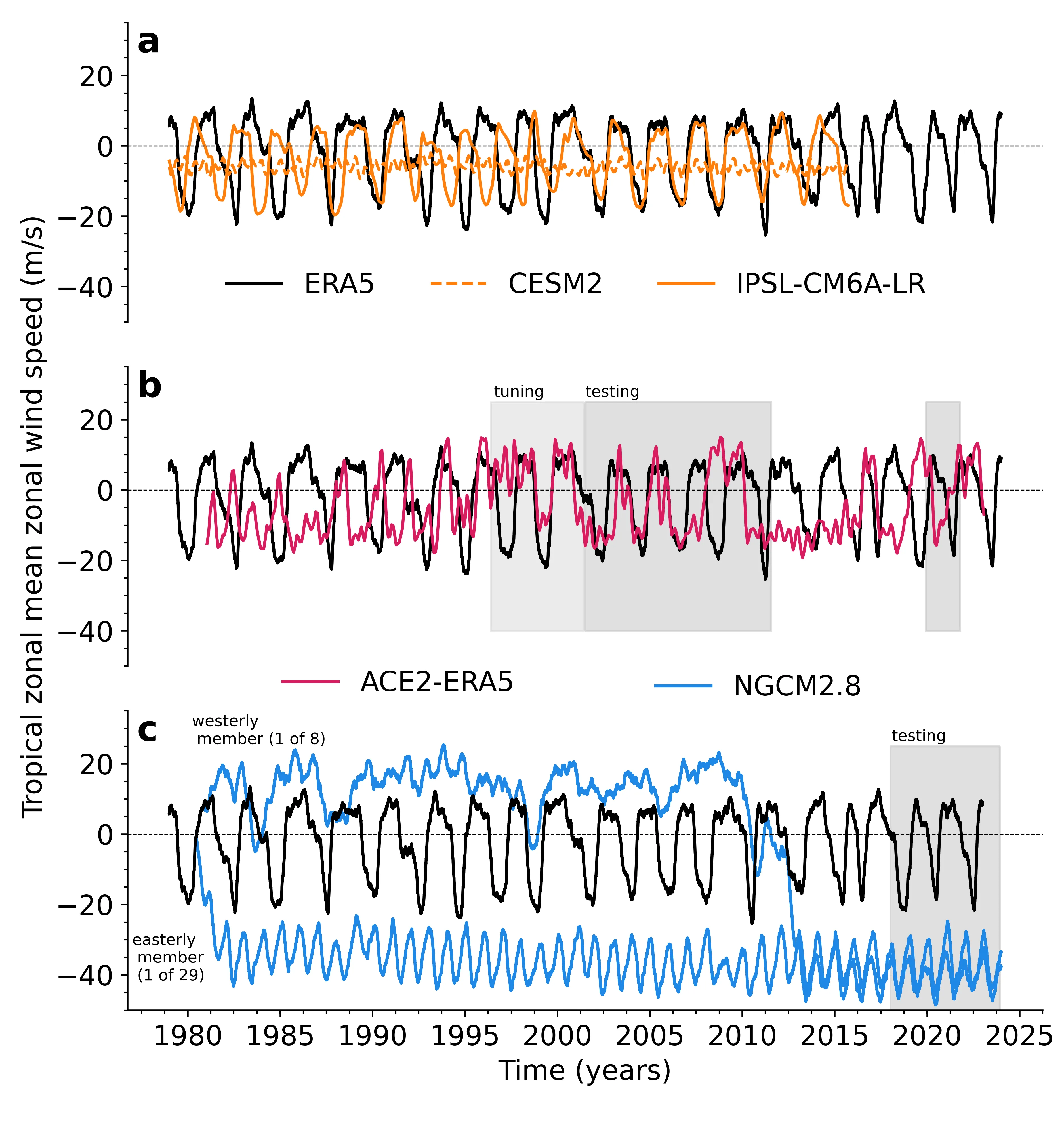
Physics-based atmosphere-land models with prescribed sea surface temperature have notable successes but also biases in their ability to represent atmospheric variability compared to observations. Recently, AI emulators and hybrid models have emerged with the potential to overcome these biases, but still require systematic evaluation against metrics grounded in fundamental atmospheric dynamics. Here, we evaluate the representation of four atmospheric variability benchmarking metrics in a fully data-driven AI emulator (ACE2-ERA5) and hybrid model (NeuralGCM). The hybrid model and emulator can capture the spectra of large-scale tropical waves and extratropical eddy-mean flow interactions, including critical levels. However, both struggle to capture the timescales associated with quasi-biennial oscillation (QBO, $\sim 28$ months) and Southern annular mode propagation ($\sim 150$ days). These dynamical metrics serve as an initial benchmarking tool to inform AI model development and understand their limitations, which may be essential for out-of-distribution applications (e.g., extrapolating to unseen climates).
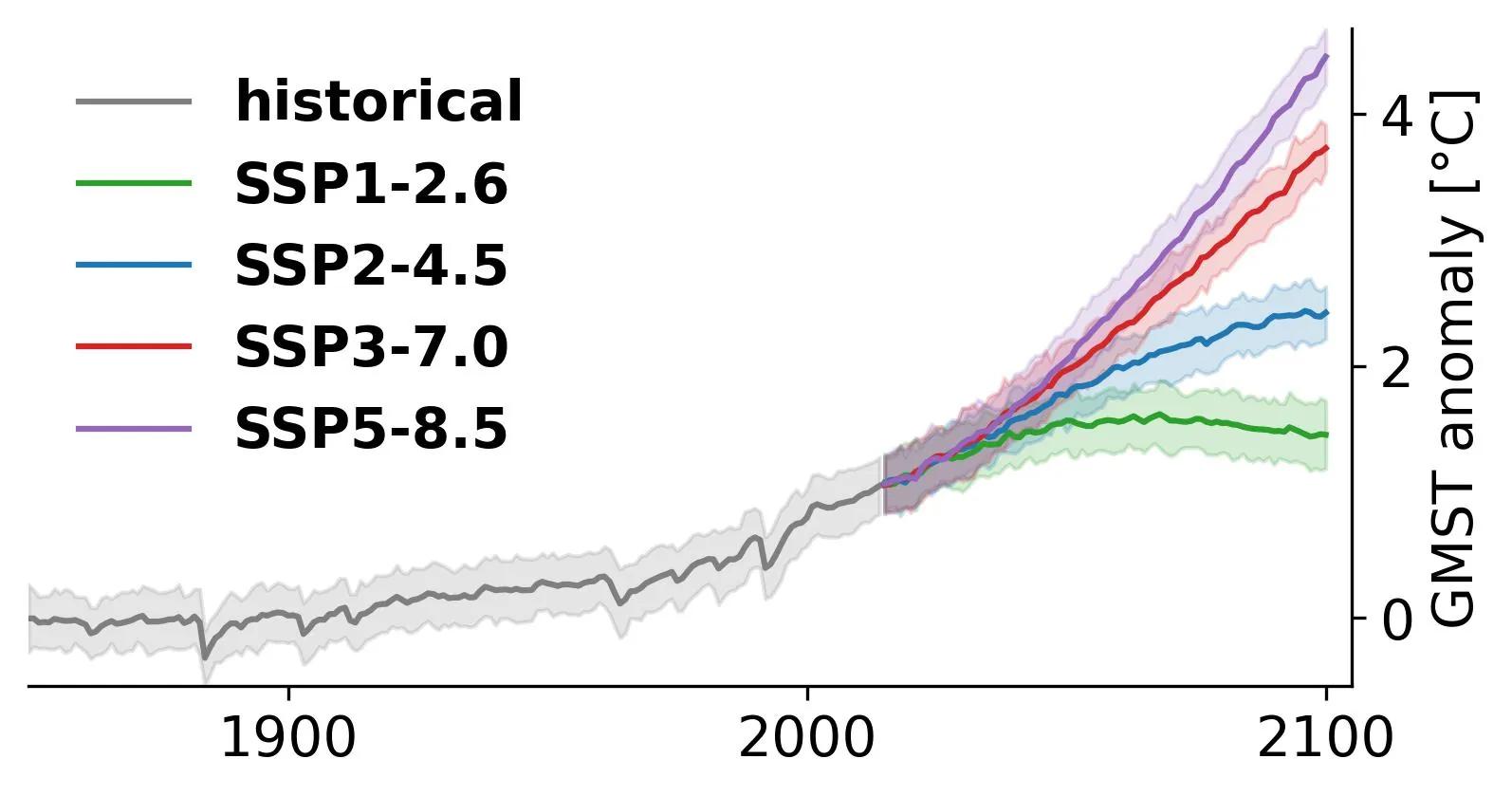
Policy targets evolve faster than the Couple Model Intercomparison Project cycles, complicating adaptation and mitigation planning that must often contend with outdated projections. Climate model output emulators address this gap by offering inexpensive surrogates that can rapidly explore alternative futures while staying close to Earth System Model (ESM) behavior. We focus on emulators designed to provide inputs to impact models. Using monthly ESM fields of near-surface temperature, precipitation, relative humidity, and wind speed, we show that deep generative models have the potential to model jointly the distribution of variables relevant for impacts. The specific model we propose uses score-based diffusion on a spherical mesh and runs on a single mid-range graphical processing unit. We introduce a thorough suite of diagnostics to compare emulator outputs with their parent ESMs, including their probability densities, cross-variable correlations, time of emergence, or tail behavior. We evaluate performance across three distinct ESMs in both pre-industrial and forced regimes. The results show that the emulator produces distributions that closely match the ESM outputs and captures key forced responses. They also reveal important failure cases, notably for variables with a strong regime shift in the seasonal cycle. Although not a perfect match to the ESM, the inaccuracies of the emulator are small relative to the scale of internal variability in ESM projections. We therefore argue that it shows potential to be useful in supporting impact assessment. We discuss priorities for future development toward daily resolution, finer spatial scales, and bias-aware training. Code is made available at https://github.com/shahineb/climemu.
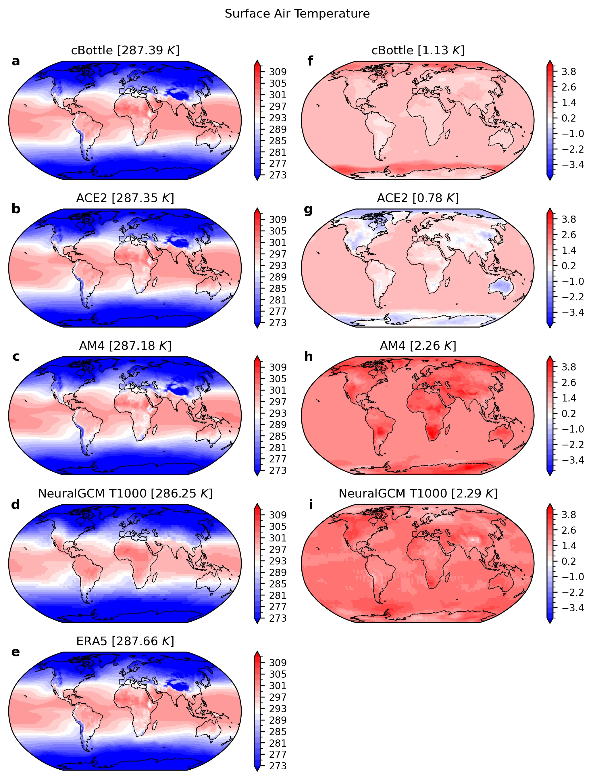
Machine learning models for the global atmosphere that are capable of producing stable, multi-year simulations of Earth's climate have recently been developed. However, the ability of these ML models to generalize beyond the training distribution remains an open question. In this study, we evaluate the climate response of several state-of-the-art ML models (ACE2-ERA5, NeuralGCM, and cBottle) to a uniform sea surface temperature warming, a widely used benchmark for evaluating climate change. We assess each ML model's performance relative to a physics-based general circulation model (GFDL's AM4) across key diagnostics, including surface air temperature, precipitation, temperature and wind profiles, and top-of-the-atmosphere radiation. While the ML models reproduce key aspects of the physical model response, particularly the response of precipitation, some exhibit notable departures from robust physical responses, including radiative responses and land region warming. Our results highlight the promise and current limitations of ML models for climate change applications and suggest that further improvements are needed for robust out-of-sample generalization.
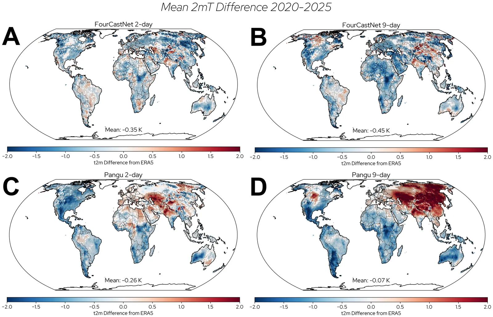
AI-based climate and weather models have rapidly gained popularity, providing faster forecasts with skill that can match or even surpass that of traditional dynamical models. Despite this success, these models face a key challenge: predicting future climates while being trained only with historical data. In this study, we investigate this issue by analyzing boreal winter land temperature biases in AI weather and climate models. We examine two weather models, FourCastNet V2 Small (FourCastNet) and Pangu Weather (Pangu), evaluating their predictions for 2020-2025 and Ai2 Climate Emulator version 2 (ACE2) for 1996-2010. These time periods lie outside of the respective models' training sets and are significantly more recent than the bulk of their training data, allowing us to assess how well the models generalize to new, i.e. more modern, conditions. We find that all three models produce cold-biased mean temperatures, resembling climates from 15-20 years earlier than the period they are predicting. In some regions, like the Eastern U.S., the predictions resemble climates from as much as 20-30 years earlier. Further analysis shows that FourCastNet's and Pangu's cold bias is strongest in the hottest predicted temperatures, indicating limited training exposure to modern extreme heat events. In contrast, ACE2's bias is more evenly distributed but largest in regions, seasons, and parts of the temperature distribution where climate change has been most pronounced. These findings underscore the challenge of training AI models exclusively on historical data and highlight the need to account for such biases when applying them to future climate prediction.
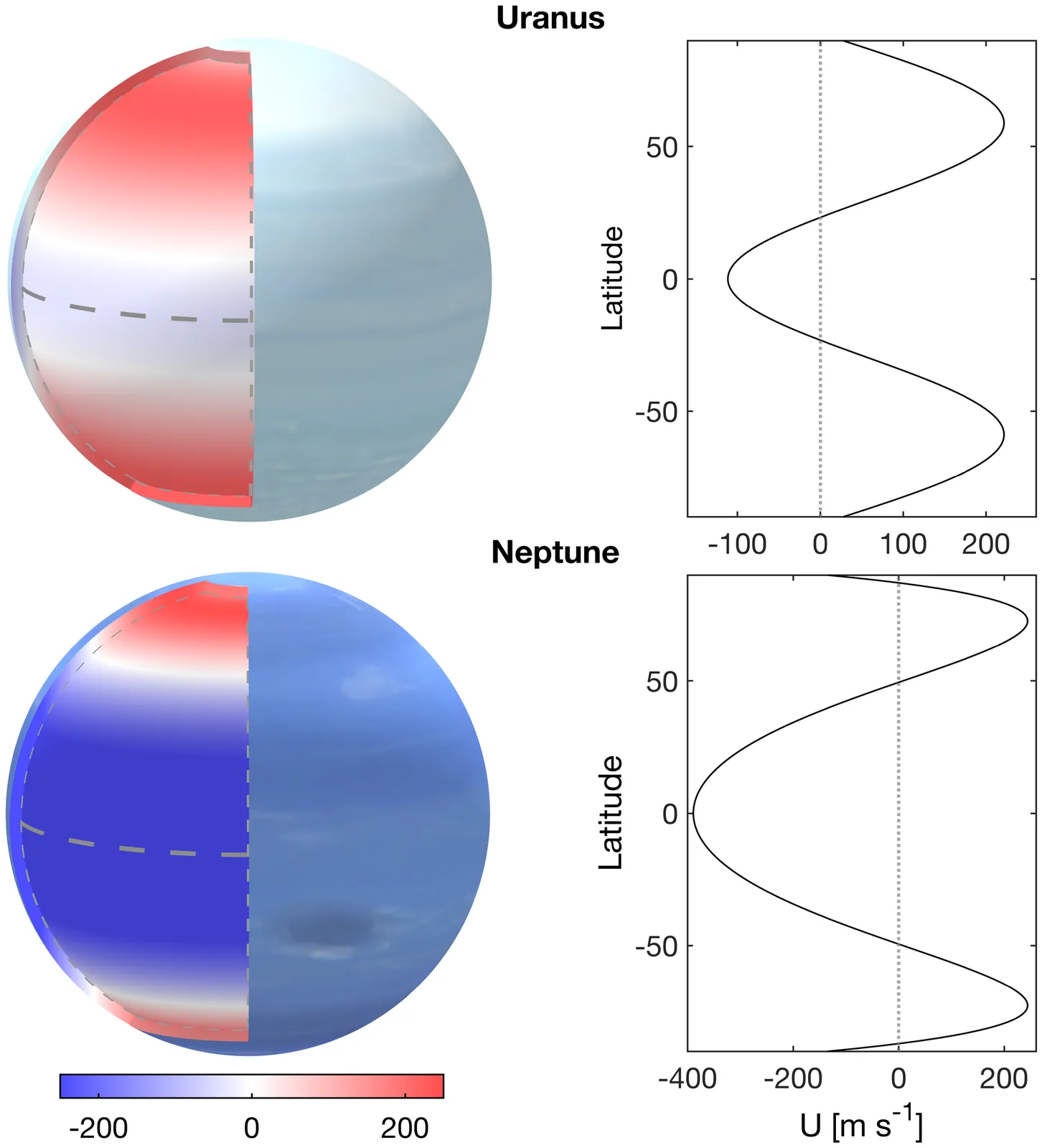
Uranus and Neptune are the least explored planets in the Solar System. A key question regarding the two planets is the similarity of their observed flows despite the great differences in their obliquity and internal heating. To answer this fundamental question and understand the ice giants atmospheric circulation, we developed a new general circulation model (GCM). This tool will also be key to facilitating the success of future missions to the ice giants, for which atmospheric flows will be a measurable quantity. Past GCMs for the ice giants have struggled to reproduce the observed winds on Uranus and Neptune. Using our idealized GCM, we systematically explored how the zonal wind and meridional circulation respond to different model and physical parameters; our main focus was on the depth of the domain. We show that in cases where the bottom layer of the model is deep enough, the simulated flow is independent of the meridional structure of the forcing temperature, indicating that dynamical processes, and not the imposed thermal forcing, are the dominant drivers of the circulation and the thermal structure. A momentum balance analysis further shows that meridional and vertical eddy momentum flux convergence are both central to maintaining the circulation. These results provide a physical explanation for the similarity of the flow on Uranus and Neptune although their solar and internal forcing are significantly different. The modeling framework developed in this study can serve as a foundation for the development of more comprehensive GCMs of the ice giants and help guide the interpretation of future mission data.
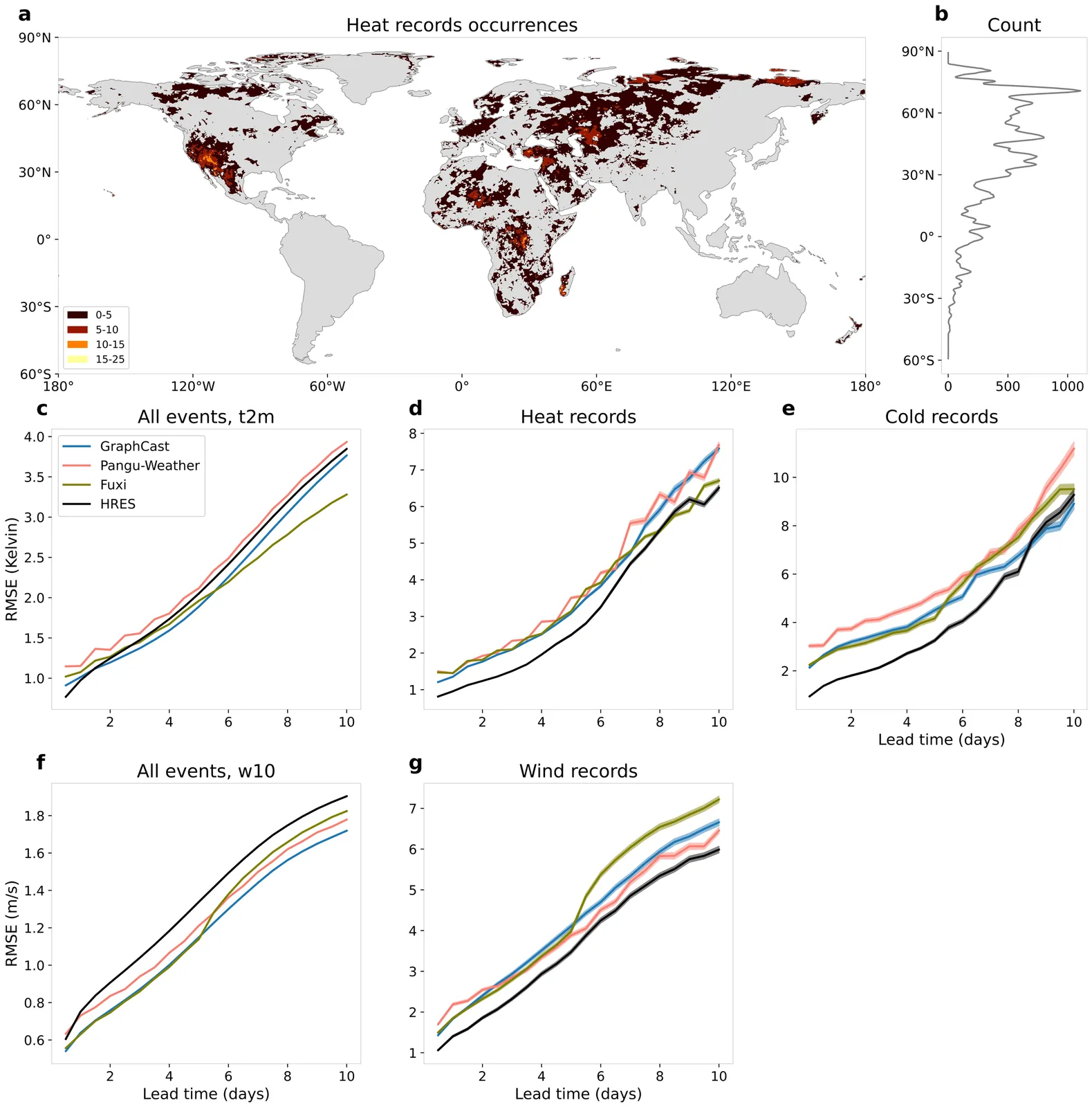
Artificial intelligence (AI)-based models are revolutionizing weather forecasting and have surpassed leading numerical weather prediction systems on various benchmark tasks. However, their ability to extrapolate and reliably forecast unprecedented extreme events remains unclear. Here, we show that for record-breaking weather extremes, the numerical model High RESolution forecast (HRES) from the European Centre for Medium-Range Weather Forecasts still consistently outperforms state-of-the-art AI models GraphCast, GraphCast operational, Pangu-Weather, Pangu-Weather operational, and Fuxi. We demonstrate that forecast errors in AI models are consistently larger for record-breaking heat, cold, and wind than in HRES across nearly all lead times. We further find that the examined AI models tend to underestimate both the frequency and intensity of record-breaking events, and they underpredict hot records and overestimate cold records with growing errors for larger record exceedance. Our findings underscore the current limitations of AI weather models in extrapolating beyond their training domain and in forecasting the potentially most impactful record-breaking weather events that are particularly frequent in a rapidly warming climate. Further rigorous verification and model development is needed before these models can be solely relied upon for high-stakes applications such as early warning systems and disaster management.